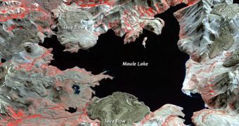
This photograph is now more than 9 years old, having been collected by the NASA Terra satellite on April 9, 2003. Yet, the passing of time has not affected its beauty. The area depicted here is the volcanic caldera named Laguna del Maule.
The image is zoomed on the northern parts of the caldera. The formation, which is about 15 by 25 kilometers (9 by 15 miles) across, is the home of Maule Lake. In addition, there are many other types of volcanic features apparent in the view.
For instance, small stratovolcanos, lava domes, and cinder cones are also apparent all around the lake. They were all made apparent by the Advanced Spaceborne Thermal Emission and Reflection Radiometer (ASTER) instrument aboard Terra.
According to NASA Earth Observatory, the areas colored in black in this image are water, earth-tones sectors are bare rock, vegetation is depicted in red and pink, and snow is shown in white.

 14 DAY TRIAL //