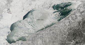
This image collected by a NASA satellite showcases Lake Erie, one of the five Great Lakes at the border between Canada and the United States. The lake is covered almost entirely in ice fields, which span roughly 90 percent of its surface.
The photo was snapped on January 9, 2014, from the NASA Aqua satellite in low Earth orbit, via its Moderate Resolution Imaging Spectroradiometer (MODIS) instrument. At the time the picture was taken, a massive front of cold air caused by the polar vortex was affecting both countries.
According to meteorologists, around 25 percent of the total surface area of the Great Lakes was covered with ice on January 9. This freeze-over also had some positive effects, in the sense that it prevented the cold winds of the polar vortex from picking up additional moisture from the lakes.
According to data released by the US National Oceanic and Atmospheric Administration's (NOAA) Great Lakes Environmental Research Lab, 88 percent of Lake Erie was frozen on January 12, and 62 percent on January 14. This reduction in ice was caused by temperatures that reverted to normal values.

 14 DAY TRIAL //