 14 DAY TRIAL //
 Google Earth is an innovative downloadable application that allows you to explore the Earth directly from your hard-disk drive. Recently, the search giant updated the program and made it compatible with Google SketchUp, a tool also provided by the company, to allow you to create 3D models of your country, city or neighborhood. This way, you can contribute to the developing process of Google Earth, adding 3D views of specific locations.
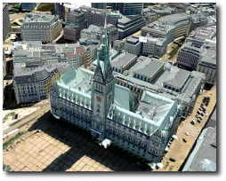
Today, Ogle Earth announced that the first city that was totally designed in 3D mode is Hamburg with buildings, roads and other elements to be included in Google Earth. "Many German news sites are abuzz just now with the announcement a few hours ago that the entire center of Hamburg has been made into a massive 3D model for Google Earth," Ogle Earth said.
Even if the 3D version of Hamburg was released, Google didn't confirm an updated version of Google Earth or an upcoming improvement into the application, so we should expect for more 3D models before the program is improved.
"This is a world premiere," said Google spokesperson Stefan Keuchel at the presentation of the project today. "With the textures on the facades [of buildings] Hamburg is the first city worldwide to be visible in this detail. Hamburg 3D will be live in a few days or weeks. The project was not initiated by Google, but by the Hamburg@Work initiative, which is sponsored by both the city and private businesses. Google spokesperson Keuchel said that Hamburg approached Google and proposed the project," Ogle Earth said.
The latest version of Google Earth was also tested by Softpedia and it is available as a free download HERE. If you want to test the power of Google Map without downloading any application, you can test the special Google Maps service accessible here.