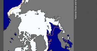
Experts with the US National Snow and Ice Data Center (NSIDC) announce that the final figures covering the full extent of Arctic sea ices for this winter have just been compiled. The average extent was the ninth lowest recorded near the North Pole since satellite observations began, in 1979.
The annual maximum extent in the Arctic was reached on March 18, scientists say. Satellite data show that the ice fields covered more than 15.24 million square kilometers (5.88 million square miles).
At its maximum extent, the ices still covered about 614,000 square kilometers (237,000 square miles) less than they did between 1979 and 2000. On average, the Arctic is covered by about 15.86 million square kilometers (6.12 million square miles) of ices.
One of the most interesting things that investigators noticed was that the maximum sea ice extent was reached about 12 days later in 2012, when compared to the 1979-to-2000 average (March 18 as opposed to March 6).
“Last year, 2011, was the lowest maximum on record, 14.64 million square kilometers (5.65 million square miles). Including this year, the nine years from 2004 to 2012 are the nine lowest maximums in the satellite record,” a NSIDC press release says.
Experts with the Center say that ice extents began declining as of March 23, but add that there is a chance they will begin to grow again, before summer sets in. However, it's very unlikely that the total amounts of ice will exceed what has already been achieved.
The new data again underlines the encroaching influence of global warming and climate change. Scientists warned years ago that these phenomena will affect the poles a lot more severely than the Equator, in the sense that temperatures here will increase faster and by wider margins.
“Sea ice extent in February and March tends to be quite variable, because ice near the edge is thin and often quite dispersed,” the same statement explains. Analysts at NSIDC will release a comprehensive study of how sea ice evolved throughout this winter in early April.
“The thin ice is highly sensitive to weather, moving or melting quickly in response to changing winds and temperatures, and it often oscillates near the maximum extent for several days or weeks, as it has done this year,” scientists with the Center add.

 14 DAY TRIAL //