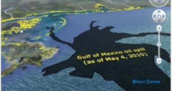
The explosion at the Deepwater Horizon off-shore drilling rig, which led to a massive amount of crude oil leaking into the Gulf of Mexico, with no signs of stopping, is proving to be one of the biggest ecological catastrophes, certainly in US history. The oil spill that has been growing for a few weeks now, has reached a massive size, so big that it’s hard to put it into perspective. One Google developer realized this and created a simple tool using the Google Earth API enabling you to compare the oil spill to the size of your home town, or any city on Earth for that matter.
“The spill covers an area of over 2,500 square miles, and shows no signs of slowing down. 2,500 square miles is a large number, but how big is that, really? It's very difficult for us to imagine something that large, and it's doubly hard to grasp the true size when it sits over the vast ocean surface,” Paul Rademacher, Google Maps Engineering Manager, wrote.
“To help understand the scale of this ecological disaster, I built a page using the Google Earth Browser Plug-in that will let you see the oil spill in comparison to something everyone has a good grasp on: the size of your own home town,” he explained.
You can head over here, on the developer’s homepage, to see the tool in action. It’s built using the Google Earth API available to anyone and you can check it out if you have the Google Earth browser plugin installed. If you have Google Earth installed and are running a supported operating system (Windows, Mac OS X), the plugin should be working.
Google already provides plenty of data on the Gulf of Mexico oil spill through a dedicated page and through the various resources it has provided for Google Earth. There is satellite imagery from several sources, NASA, ESA, and various overlays. You can find out more about how to keep track of the oil spill here.

 14 DAY TRIAL //