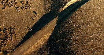
After more than a year after the April 4, 2010 Baja California earthquake, geologists are beginning to piece together what happened. They are very interested in why the shallow, magnitude-7.2 tremor occurred at depth of only 10 kilometers (6.2 miles),
Seismologists identified the epicenter of the second-largest earthquake ever to hit Baja California in a region located about 40 miles south of the US-Mexico border. The main event was followed by several aftershock in the following months.
Some of these aftershocks were even felt in Los Angeles. Due to its date, the event became known as the Easter Earthquake, It is also one of the favorite events of this type for geologists, for two reasons.
First, they were able to monitor the temblor using sensors in orbit, in the air and on the ground, which made the event one of the most data-rich earthquakes in history. Second, the epicenter was located relatively close to the dormant San Andreas fault line.
This made experts suspect that the shaking may have activated some of the fault regions, potentially increased the risk of tremors occurring on the United States West Coast.
“The southern San Andreas Fault has not had a major earthquake on it since the 1600s. So every time there’s an earthquake down in that region, everyone gets very worried that it’s going to rupture northward and continue propagating up. That is a very reasonable fear,” says Thomas Herring.
The expert holds an appointment as a professor of geophysics in the Department of Earth, Atmospheric and Planetary Sciences at the Massachusetts Institute of Technology (MIT), in Cambridge.
The expert and his team were responsible for mapping the path the earthquake took in tremendous detail. They found that a second earthquake occurred about 15 seconds after the main one, and also that the event had triggered the rupture of two deep fault lines that were previously thought to be inactive.
Full details of the team's results were published in the July 31 online issue of the top scientific journal Nature Geoscience. “Understanding how stresses in the Earth release and build up could help us understand how one earthquake sets off another over a long time scale,” Herring explains.
“Getting more refined at understanding these interactions is something I think we can make progress on in the next decade,” he goes on to say. His team was able to piece together what happened with a relatively high degree of certainty.
After the first earthquake occurred, the second one was produced by the two inactive fault lines, which ruptured due to the pressure the magnitude 7.2 event placed on them. The first ruptured northwards, while the other in the exactly opposite direction.

 14 DAY TRIAL //