The greatest cycling competition, the Tour de France, just got underway yesterday and lovers of the sport have every reason to be excited. For the next 21 days, the world’s best riders will battle it out for the greatest honor in cycling, to be the winner of the Tour de France.
A lot of people will be camping out and following the tour on site, but most of us will be watching back home. Thankfully, there are several ways of getting detailed information on this year’s course from both Bing Maps and Google Earth.
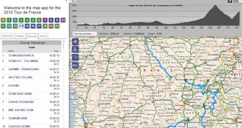
Bing Maps has put together an app full of data on each of the 21 stages. The app, built with Silverlight, is a great tool for anyone wanting to check out future stages or get more context for the ones underway. Besides the obvious courses for all stages, the app features an elevation and distance graph to give you an idea of the type of climbs the riders will encounter.
There is also weather information, ten days ahead, and it looks like this year the riders will experience some rather sunny and pleasant conditions. The app provides information on the current standings and the rankings for each completed stage. And the tool is useful to those following the tour on the spot as it features some of the more interesting sections like sprints and hill climbs.
Google isn’t providing any tools or data officially, but fans of the sport have already created KML files for Google Earth of the complete Tour de France. Viewing all the stages in three dimensions really underlines the difficult terrain the riders encounter in some of the stages especially, the ones in the Alps. You can download a KML file with all the stages created by Thomas Vergouwen from here. [via Google Earth Blog]

 14 DAY TRIAL //