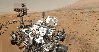
NASA's Curiosity rover, launched in November 2011, landed on the surface of the Red Planet in August 2012. The probe has since been exploring the Gale Crater, which scientists say measures about 154 kilometers (95.6 miles) across and formed some 3.5 to 3.8 billion years back.
In September 2014, Curiosity at long last reached the base of Mount Sharp, otherwise known as Aeolis Mons by its more official moniker. Mount Sharp is the central peak in Gale Crater. It stands about 5.5 kilometers (3.4 miles) tall and astronomers describe it as a gargantuan mound of sedimentary rock.
Having spent some time exploring Mount Sharp's surroundings, the rover eventually put on its hiking boots and got busy scaling it. It has so far come across a couple of sedimentary layers, which it examined looking to understand the mount's anatomy and how ancient environmental conditions modeled it.
As explained by mission scientists over at NASA, the base of Mars' Mount Sharp comprises a layer of mudstone, i.e. fine grained sedimentary rock made up of cemented clays or muds. This first layer appears to have been deposited by an ancient lake that once covered much of the planet's Gale Crater.
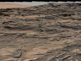
Over this deposit of mudstone sits another geological layer that researchers call the Stimson unit. While exploring this second layer, Curiosity came across a collection of petrified sand dunes. The outcrop is revealed in a panoramic view revealed by NASA just yesterday and available in the gallery below.
The view comprises dozens of images
This panorama showing dark sand dunes cemented into rock on the surface of the Red Planet comprises dozens of images that NASA's Curiosity rover obtained with the help of its Mast Camera just a couple of weeks ago, on August 27.
The robotic explorer has since moved away from the petrified dunes, but it is still busy exploring Mount Sharp's Stimson unit. Later this month, mission scientists plan to have it drill into this layer and collect a soil sample for analysis.
“The dozens of individual Mastcam images combined into this panorama were taken on Aug. 27, 2015. Curiosity has driven about 103 yards (94 meters) in the subsequent two weeks, generally southward,” NASA writes in an update.
“Outcrops of the Stimson unit sandstone are still accessible to the rover, and researchers plan to use the rover to collect and analyze a drilled sample of Stimson unit sandstone this month,” the space agency further details.
As mentioned, the formations revealed in this latest panoramic view of Mars started out as sand dunes and, in time, were cemented into rock. Researchers say they owe their rather disorderly shape to winds that shaped them before they turned into stone.

 14 DAY TRIAL //
