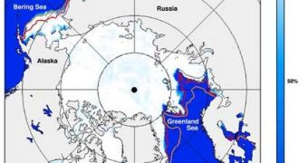
The summer of 2007 registered the record of ice melting in the Arctic. Now, satellite data obtained by NASA reveals that the Arctic ice has recovered weakly, despite a very cold winter, and this summer melting could be another hit.
In some Arctic areas, the colder-than-average winter of 2007-2008 has caused an increase in the area of new sea ice, but this can do little for stopping the decline of the perennial sea ice, an indicator of the longer-term warming climate trend causing accelerated summer melting and greater displacement of the older Arctic ice.
Perennial sea ice, accumulated along the years from what was left over after the summer melt period, used to cover 50-60% of the Arctic, as showed by NASA researchers; but in September 2007, this ice represented less than 30%. Ice standing in the Arctic for at least six years represented over 20% of the Arctic area in the mid to late 1980s, but in the winter of 2007-2008, this ice was just 6%.
"As ice ages it continues to grow and thicken, so that older ice is generally also thicker ice. This winter the ice cover is much thinner overall and thus in a more vulnerable state heading into the summer melt season. NASA's ICESat satellite has contributed to understanding of the changes in ice thickness. To get a better understanding of the behavior of sea ice, NASA is planning a follow-on satellite mission, ICESat II, to launch in 2015," said Walt Meier of the National Snow and Ice Data Center at the University of Colorado, Boulder.
Arctic sea ice varies between the seasons, getting an average minimum surface of 2.5 million square miles (6.2 million square km) in September, and expanding to an average winter maximum of 5.9 million square miles (15 million square km) in March.
NASA's Aqua satellite and NOAA and U.S. Defense Department satellites determined that in March 2007, the maximum sea ice surface has grown by 3.9% over the value of the previous three years, but it has remained under the long-term average by 2.2%. The greatest ice advances took place in areas that registered lower temperature values than the historical averages.
But the perennial ice cover decreased by 40% in September 2007, less than the 28-year average. NASA measurements also showed that the perennial ice in March 2008 has dropped from about 40% of the total ice pack in March 2007 to 30%. The perennial ice is also turning younger, thus thinner and more vulnerable to summer melting.

 14 DAY TRIAL //