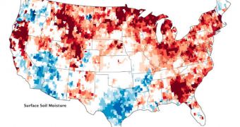
Underground water supplies throughout most of the United States are still severely depleted, as evidenced in new maps compiled from data relayed by NASA satellites. Most of these supplies, including aquifers, are currently heavily exploited for drinking water and farming.
The drought that struck the country throughout most of 2012 runs deep, and is extremely persistent. The Gravity Recovery and Climate Experiment (GRACE) twin satellites produced three maps showing the extent of the damage, as seen above (click the image to see all three).
The colors indicate the extent of the anomaly from the 1948-to-2009 average values of water availability. Blue represents areas where more water was available this year, while yellow, orange and red colors indicates regions where a lot of water was lost.
Throughout September 2012, the eastern third of the United States, the Midwest, the High Plains and Rockies, and the area along the California–Oregon border remained severely affected by drought.

 14 DAY TRIAL //