The conclusions of a new scientific investigation reveal that several large-scale climate patterns interacted in such a way during December 2011 that they were able to prevent snowfall from falling over huge parts of North America and Europe.
The month was one of the driest on record in the United States, as well as one of the warmest. Snowfall was negligible throughout the country, a far cry from the impressive snowstorms that struck the country over the past couple of years.
Investigators set out to figure out what happened right away, and determined that this state of affairs was largely triggered from two main directions – interactions between the National Atlantic Oscillation (NAO), the Arctic Oscillation (AO) and La Niña, and shifting climate patterns.
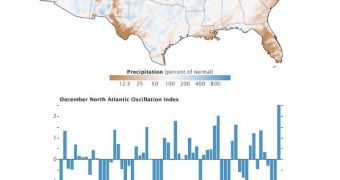
The map to the left illustrates abnormalities that occurred in precipitation patterns throughout the month of December. An unusual jet stream and the unseasonal weather caused temperatures to remain high, while at the same time preventing snow from reaching the surface.
Even in areas where precipitations were forming, most of the water came down as rain rather than snow. “The top map shows December precipitation across the lower 48 United States as a percentage of normal for the month,” a press release from the NASA Jet Propulsion Laboratory (JPL) reads.
“The middle graph depicts an index of the National Atlantic Oscillation (NAO) for every December since 1950. The lower graph shows an index of the Arctic Oscillation (AO) for the same period. A third piece of the puzzle – La Niña – is shown” here, the document adds.
While the United States were largely spared by the massive snowfalls of previous years, the same cannot be said for Canada and Greenland, which both experienced cold and dry weather. This happened because atmospheric pressure is higher in the subtropical Atlantic and lower in the North Atlantic.
At the same time, areas bordering the Arctic Circle exhibited pressure systems fluctuations, known collectively as the Arctic Oscillation. High pressure and a positive AO mean that cold air masses are contained high in the atmosphere, in a circular pattern above the North Pole.
When air pressure weakens, and the AO turns negative, those masses of cold air leak out and flow down to mid-latitude in the United States and Europe, bringing freezing temperatures along with them.
“This winter's remarkable AO/NAO pattern stands in stark contrast to what occurred the previous two winters, when we had the most extreme December jet stream patterns on record in the opposite direction (a strongly negative AO/NAO),” meteorologist Jeff Masters explains.
“The December Arctic Oscillation index has fluctuated wildly over the past six years, with the two most extreme positive and two most extreme negative values on record,” he goes on to say.
“Unfortunately, we don't understand why the AO varies so much from winter to winter, nor why the AO has taken on such extreme configurations during four of the past six winters,” Masters concludes.

 14 DAY TRIAL //