 14 DAY TRIAL //
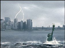
 What's with all the fuss about the global warming? In the end, the greatest warming will occur at the Poles... No ice? So what, no seals and no polar bears. Well, you may add no home for 1 billion people...
A new mapping technique developed by the U.S. Geological Survey can now reveal you how much land would be engulfed by water in a case of rapid sea level rises, either from tsunamis or ice melting.
"Nearly one-quarter of the world's population lives below 100 feet (30 m) above sea level - the size of the biggest surge during the 2004 tsunami that pulverized villages along the Indian Ocean and killed 230,000 people. What we are suggesting is what kind of areas are at risk (in) a catastrophic event," said lead researcher, Lynn Usery.
A 100 ft rise in sea level was found to cover 3.7 million square miles (9.5 million square km) of land worldwide and a rise of just 16 feet (5 m) would drown the home of 669 million people (about 2 million square miles or 5.1 of square km land).
"Sea levels are currently rising about 0.04 to 0.08 inches (1 to 2 millimeters) each year, making it unlikely such a scenario would suddenly occur across the globe," Usery said.
Still, the researchers warned that, 10,000 years ago, at the end of the Ice Age, sea levels rose with 20 m (66 ft) in just 500 years. "It can happen in a short period of time if we look at the historical data," Usery said.
"Within the next century, if nothing is done to modify New Orleans' existing infrastructure, some areas of the city that did not flood as a result of Hurricane Katrina will likely flood in a future storm due to subsidence and sea-level rise. Complete melting of the Antarctic and Greenland ice sheets could lead to a sea-level rise of about 80 meters, while melting of all other glaciers could lead to a sea-level rise of only half a meter." the USGS stated.
The new mapping technique was developed with the goal of offering to policymakers better tools to face potential disasters. "This can be used by nations in the world to put contingency plans in place. We haven't had data sets at this kind of resolution before." said Usery.
People use to think that sea rise level will affect just renown low-lying areas like the Netherlands or many Pacific islands, without realizing the real dimension of the disaster.
"A 30-meter surge in Florida would leave the whole state covered except for a little plateau area," Usery said.