A team of researchers from the University of Iceland in Reykjavik, led by geophysicist Sigrún Hreinsdóttir, demonstrated in a study published yesterday, January 12, that active volcanoes may shift their location slightly before erupting.
This discovery could open the way towards a new series of early-detection and warning methods, which would allow people living in areas immediately adjacent to active volcanoes to vacate these regions at the first signs of trouble.
Details of this investigation, which relies on data the collectors gathered from a Global Positioning System (GPS) instrument installed on the slopes of Iceland's Grímsvötn volcano, appear in the January 12 issue of the top scientific journal Nature Geoscience.
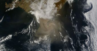
In May 2011, the 1,725-meter (5,659-foot) Grímsvötn volcano in southeastern Iceland erupted, spewing an ash plume around 20 kilometers (12.5 miles) high. A GPS instrument that was monitoring the peak determined that the crater shifted by around 0.5 meters (1.6 feet) right before the blast.
The team at the University of Iceland believes that such lurches are exhibited by all volcanoes that are getting ready to erupt. The researchers also argue that the amount of shift recorded before blasts provide a relatively-accurate estimate of how intense the eruptions will be, Nature News reports.
“A GPS site can tell you not only that there’s unrest at a volcano, but that it’s about to erupt and then how high its plume will be,” Hreinsdóttir explains. A system that would feed such data to authorities in eruption-prone areas would enable them to close off roads and evacuate residents in due time, potentially saving many lives.
At the same time, knowing the approximate altitude an ash plume will reach is of great importance for airline safety, since pilots would be notified of any developing ash clouds well in advance, and steer clear of them.
When the Eyjafjallajökull volcano erupted in 2010, numerous flights had to be canceled throughout Northern Europe, especially in the United Kingdom. The 2011 Grímsvötn event, the largest eruption in Iceland in more than 100 years, did not cause as many cancellations, but did serve as a warning sign.
Hreinsdóttir says that her team will get a chance to confirm the results of this new study as soon as another volcano erupts in Iceland. Most of the mountains featuring geologically-active craters are already being monitored with GPS instruments.

 14 DAY TRIAL //