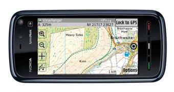
The leading outdoor GPS navigation software for mobile phones, ViewRanger, has now become available for the Nokia 5800 and other Symbian S60 touchscreen devices. The application is able to benefit from the touch screen to deliver detailed topographic maps while also offering a simplified navigation and outdoor exploration experience.
ViewRanger comes as an easy-to-use off-road satellite navigation application that is able to deliver access to topographic mapping across Europe, as well as points-of-interest and leisure route guides. Users can download maps directly to the phone either using WLAN or mobile Internet. At the same time, maps are also available for download via the web to be side-loaded onto a handset, or are available pre-loaded on SD memory-cards.
The Nokia 5800 XpressMusic presents itself as a great option for running ViewRanger, given the fact that the handset's high-resolution 3.2" widescreen display is able to deliver the detailed topographic maps with great clarity. At the same time, the phone's 3.2-megapixel camera with Carl Zeiss lens is perfect for geo-recording while on the road. Moreover, ViewRanger's TravelLog capability enables users to share their experiences with friends.
The Nokia 5800 XpressMusic can offer a rapid and intuitive manipulation of the topographic map. “Maps can be dragged, routes and points-of-interest selected, and key features are available, literally, at your fingertips. Where ViewRanger's 3D Panorama maps are available, you can point at a landscape feature such as a hill and ViewRanger will identify and name that feature. You can then browse photos and information that other users have uploaded and associated with that feature.”
The application also includes extensions like ViewRanger's BuddyBeacon tracking capability. Moreover, the partnership with Retrieva Tracking Ltd allows users to navigate to their dogs via BuddyBeacon support for Retrieva's upcoming GPS-enabled dog collar. The phone's Landmark database is also supported, so that users can benefit from both the ViewRanger and other road-based mapping.
The ViewRanger personal outdoor navigation software delivers detailed topographic maps for a growing global community that includes Belgium, Finland, France, Germany, Great Britain, Holland, Ireland, parts of Italy, Norway, Slovenia and Switzerland.

 14 DAY TRIAL //