Right before it was decommissioned on July 6, the second European Remote Sensing satellite (ERS-2) sent back a final treasure trove of glacier data, that masterfully crowned its amazing, 16-year mission.
A large part of the measuring methods current satellites use were first tested and validated aboard this testbed spacecraft. This was a pioneering mission in every sense of the word, officials at the European Space Agency (ESA) say.
The first spacecraft of the series, dubbed ERS-1, launched back in 1991, while ERS-2 took to the skies in 1995. Since then, the latter has been conducting scientific studies of our planet, providing mission controllers with a wealth of data that they didn't even dare to hope for.
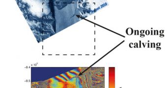
One of the spacecraft's final sets of observations covered the Kangerdlugssuaq glacier in Greenland, the island that holds a vast ice sheet, one of the largest in the world. Together with the Arctic and Antarctica, this area holds most of Earth's ice reserves.
Recently, ERS-2 began conducting observations of the glacier once every 3 days, rather than once every 35 days, as usually. This allowed experts at ESA to discover the rapidly changing glacial features that the massive volume of ice displayed.
Radar images covered the entire region constantly, between March and May 2011. The datasets show that the glacier is advancing at a steady pace of about 35 meters (roughly 114 feet) per day. But this flow was abruptly cut between May 19-22.
At that time, a huge, 9-square-kilometer piece of the glacier simply split into icebergs, and began flowing away. Over the past 19 years, Kangerdlugssuaq's calving front has retreated by more than five kilometers, as evidenced by comparisons between ERS-1 and ERS-2 data.
“The data have revealed continued acceleration and retreat of glaciers in both Antarctica and Greenland, and are certain to become one of the most important records of climate change during the satellite era,” University of Leeds professor Andrew Shepherd explains.
“Now that ERS-2 is retired, no other flying or planned satellite is able to accurately detect the grounding line location of ice streams. This will make the data gathered by ERS-2 during its final months all the more valuable for scientists,” says Marcus Engdahl.
The expert is the ESA scientific coordinator of the ERS-2 Ice Phase. In addition to glaciers, the satellite also used to measure ozone levels, sea-level heights and surface temperatures. All investigations were conducted with the main instrument, an advanced synthetic aperture radar (SAR),

 14 DAY TRIAL //