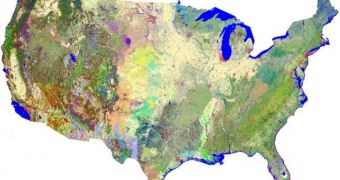
Experts at the US Geological Survey (USGS) have just released the most detailed and up-to-date map of the vegetation cover in the United States. Given the encroachment of human activities in previously-pristine natural habitats, it stands to reason that conservations experts will require a new tool to assess where in the country wildlife can survive. This could help inform conservation efforts better, so that as few species as possible are completely wiped out due to human activities, ScienceDaily reports.
“These data are critical for determining the status of biodiversity, as baseline data for assessing climate change impacts, and for predicting the availability of habitat for wildlife. Large datasets of this type are extremely important to land and wildlife managers because they allow for analysis and planning across extensive geographic areas,” explains USGS Gap Analysis Program (GAP) Manager John Mosesso. The tool is available for viewing and download online here.
All GAP data are part of the USGS National Biological Information Infrastructure (NBII). This is a biological resources-oriented program that strives to make sharing such information between various agencies and research groups a lot easier. Already, the new datasets have been sent to a large number of research groups, dealing in fields ranging from basic research to comprehensive state wildlife plans and educational projects. One of the main advantages of using the GAP information is that they contain the most accurate knowledge on the status of numerous species, living in locations all over the US.
Overall, in excess of 551 Ecological Systems and modified Ecological Systems are included in the new map, which can be accessed in three different levels of complexity. This option was built in so that the general public could make sense of what's going on in the country by simply gazing over the tool. The most complex level is destined for professionals, and is meant to provide the most insightful study experience possible. Some analysts have already predicted that GAP will become very popular, for the simple reason that it transcends political boundaries, providing experts with integrated, nation-wide data.

 14 DAY TRIAL //