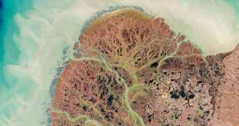
The Enhanced Thematic Mapper Plus (ETMP) instrument on the NASA Landsat 7 satellite has recently imaged the Yukon River as it meanders its way through a rugged, beautiful tundra plain, towards the Bearing Sea and a large delta.
Yukon River flows from British Columbia, Canada, into the aptly-named Yukon Territory, Alaska, and then finally into the Bering Sea, alongside the Kuskokwim River. The delta is located in the southwestern parts of Alaska.
One of the things that immediately catch the eye in this image is the large number of coastal ponds and lakes, which are fed by a multitude of interweaving streams and rivers branching off from the Yukon. Their interactions look like blood vessels feeding the tundra, from above.
The location where the delta now lies was once a critical point for animals and human ancestors to move from Eurasia to North America. Some 20,000 years ago, an expanse of land called Beringia was exposed when glaciers caused a decrease in sea levels, connecting the two continents directly.

 14 DAY TRIAL //