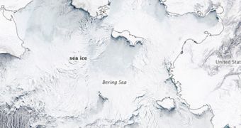
One of the most puzzling aspects of the 2011-2012 winter in the areas around the North Pole was the unusually-high sea ice extent present in the Bering Sea, according to a report provided by the US National Snow and Ice Data Center (NSIDC).
This natural-color image of the sea basin was captured on March 10, 2012, using the NASA Aqua satellite's Moderate Resolution Imaging Spectroradiometer (MODIS) instrument. Black lines marking the coastlines have been overlaid on the image.
The ice extent totaled 562,000 square kilometers this January, which is about 104,600 square kilometers above the 1979 to 2000 average. Satellite records of sea ice extent began being kept in 1979, when the first dedicated observations satellites were launched.
The situation in the Bering Sea was unfortunately not echoed at other locations in the Arctic. Overall, the North Pole was covered in much less ice than the long-term average, experts say.

 14 DAY TRIAL //