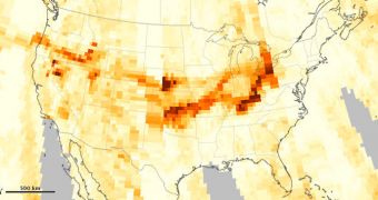
An image collected by the Ozone Mapper Profiler Suite (OMPS) instrument on the Suomi National Polar-orbiting Partnership (Suomi-NPP) satellite just 4 days ago shows heavy aerosol concentrations above the United States.
The dataset quantifies air quality over the entire country. The increased aerosol amounts originate in the intense wildfires that affected forests in California and Idaho. Plumes of smoke made their way eastwards, all the way to the Midwest.
“On August 14, 2012, a band of dense aerosols stretched from the West Coast through Wyoming. The next day, thick aerosols collected over parts of North Dakota, Kansas, Oklahoma, and Texas,” experts at NASA reports.
Suomi NPP launched to orbit aboard a Delta II rocket on October 28, 2011, from Space Launch Complex 2W (SLC-2W), at the Vandenberg Air Force Base (VAFB), in California. Its mission is scheduled to conclude after 5 years.

 14 DAY TRIAL //