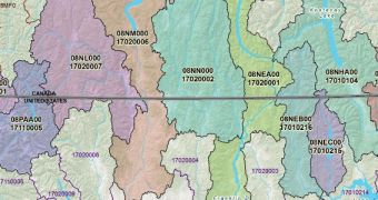
Researchers at the US Geological Survey (USGS) announced that scientists in the United States and Canada recently managed to merge hydrological maps covering water basins across the border between the two countries. The drainage systems on both sides can now be analyzed in greater detail than ever.
For example, the new system might enable scientists to better track the levels of phosphorous flowing from Lake Champlain in Vermont into Quebec, something that would have been very difficult to do based on two different hydrological maps.
“In the past, cross-border maps were not always accurate, but now these new digital maps are fully linked across the entire US and Canadian border. This cooperative project allows scientists on either side to look at the water just as nature does, irrespective of the artificial line separating the two nations,” says Peter Steeves.
The expert holds an appointment as a physical scientist with the USGS. The Survey has been compiling digital hydrological maps of the United States for the past 20 years, with the help of the Geographic Information Systems (GIS). USGS partnered with Natural Resources Canada (NRCan) for this effort.

 14 DAY TRIAL //