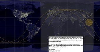
Orbital scientists say that the falling Upper Atmosphere Research Satellite (UARS) will not impact the ground over US territory. According to the latest predictions, it will splash in the South Pacific Ocean, a little to the north of New Guinea.
Over the past few days, experts have been hard at work in analyzing the trajectory the UARS took when it began its descent, as well as all the other factors that may be involved in altering this course.
This is very complex task, especially when considering that even solar activity can influence the rate at which a spacecraft is influenced and pulled by the atmosphere. However, researchers from NASA and the US Air Force (USAF) managed to understand UARS' path in more detail.
In addition, amateur astronomers and skywatchers have also been keeping an eye on the satellite, working with NASA to centralize the data. In the end, this proved to be useful for narrowing down the possible time windows when the satellite was expected.
A post published on the NASA website on Thursday, September 22, indicates that the UARS has entered a 115-by-120 mile (185-by-195 kilometer) orbit around the planet, and that reentry is therefore expected to occur sometimes during Friday afternoon (EDT).
Experts also said that there will be night at the location where the impact is expected to occur, giving people an early warning about the incoming spacecraft. “The satellite will not be passing over North America during that time period,” the NASA post said yesterday.
“It is still too early to predict the time and location of re-entry with any more certainty, but predictions will become more refined in the next 24 to 36 hours,” the agency announced. The Joint Space Operations Center of US Strategic Command contributed to tracking the satellite as well.
Expert Ted Molczan, who is using United States Strategic Command (USSTRATCOM) orbital elements to determine where the 6.5-ton spacecraft will impact the ground, says that scientists will not be able to determine exactly where UARS will impact until it does.
“I am making these estimates to maintain awareness of the approximate decay time, to maximize my chances of seeing the event,” Molczan explains, as quoted by Space. He says that the satellite's debris trail will cover almost 500 kilometers (310 miles) in length.
“If, within a few hours of the decay, it appears that it will occur on a revolution that spends some time above my horizon, then, weather permitting, I will go out and watch for it during the several minutes in which it might pass,” he concludes.

 14 DAY TRIAL //