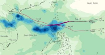
Typhoon Nesat and super typhoon Nalgae passed over the Philippines Archipelago and important parts of southeastern Asia over the past five days, drenching the region in massive amounts of rainfall. The paths they took and the rain they released are documented in this chart.
The document covers a time span stretching from September 26 to October 2, which is when most of the precipitations fell. According to meteorologists, the storms released just as much rain in five days as the area receives over several months.
The northern Philippines, northern parts of Vietnam and the island of Hainan, belonging to China, were the worst-hit by the precipitations. The darkest blue on this map indicates the heaviest average rainfalls for this time frame, about 14 inches or 350 millimeters.
Experts at the NASA Goddard Space Flight Center (GSFC) Multisatellite Precipitation Analysis (MPA) center used data from numerous US satellites to compile measurements of rainfall, and then cross-checked the results with information from the Tropical Rainfall Measuring Mission (TRMM) spacecraft.

 14 DAY TRIAL //