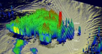
The NASA Tropical Rainfall Measuring Mission (TRMM) satellite flew above Tropical Storm Koji on March 8, at around 20:53 UTC. Data obtained by the spacecraft were just centralized into a 3D model showing the inner structure of the storm.
As seen in the image above (click for full resolution), the tropical storm displays so-called hot towers, pillar-like structures that store massive amounts of latent heat. Bands of heavy rainfall were also seen spiraling into the center of the storm.
Experts believe that Koji will become increasingly powerful over the coming days. This analysis is based on information collected by the Microwave Imager (TMI) and Precipitation Radar (PR) instruments aboard the TRMM.
Koji is expected to develop winds of up to 70knots, or about 80 miles per hour, very soon.

 14 DAY TRIAL //