 14 DAY TRIAL //
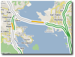
 Google Maps, the online map service provided by the search giant receives another update from the search giant, being now able to display traffic conditions for certain cities included in the product. The function is extremely useful for some regions because it will display a red route for rush-hour traffic, yellow for a little delay caused by the traffic and green for free roads.
"There's nothing worse than getting stuck in traffic when you have some place to go, so I'm happy to tell you about a new feature on Google Maps that can help. For more than 30 major U.S. cities, you can now see up-to-date traffic conditions to help you plan your schedule and route. If you're in San Francisco, New York , Chicago, Dallas, or any of the other cities we now include, just click on the traffic button to show current traffic speeds directly on the map. If your route shows red, you're looking at a stop-and-go commute; yellow, you could be a little late for dinner; green, you've got smooth sailing," David Wang, Software Engineer, sustained on the official blog.
It seems like the search giant makes a habit from updating Google Maps because the company recently added subway stations for certain locations in the US while today it announced a new function for the product. I guess Google really wants to make the map service more popular because even terrorists were using the solution to organize attacks against the UK troops. The terrorists were connecting to the product to analyze the area and launched attacks against the army located in Basra. As you might know, Google Maps is also used by researchers from all around the world to monitor the volcanoes' activity in certain locations.