The Internet of Things is starting to get more and more recognition, both as a term and as a concept, and for good reason. While the Internet as we know it today is fairly different from the one even a decade earlier, one of the biggest revolutions is still to come. In the not so distant future, every electronic gadget or appliance, every ‘thing,’ is going to be connected to the web, pouring massive amounts of data into the system. Already, some of the things that are connected would surprise you, like the London Underground trains.
The city has been pushing forward with a massive plan to have all the data it has under its administration available to all. The Transport for London API, for example, was launched just a couple of weeks ago and developers are already having a field day. While, initially, enabling access to information like the location of stations and other less exciting data, now it also provides access to data like the real-time location of the Underground trains.
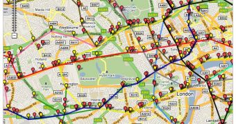
And developers have wasted no time in putting that to work, coming up with a simple yet impressive app which simply adds the train locations on top of Google Maps. The map is updated in real time so you can track the movement of each train from your laptop or mobile phone. It’s a simple tool somewhat hastily put together, but it’s a very good way of showing what’s possible when the web and the ever increasing computerized systems running the world’s infrastructure come together.
The live train map is useful as it is and since it’s a web app it can be accessed from a variety of devices. Still, a dedicated app for the iPhone or Android devices would surely prove very popular with Londoners and you can be pretty sure that someone out there is already working on it.

 14 DAY TRIAL //