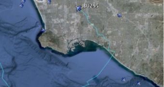
Google Earth comes packed with a plethora of information. And since it's connected to the web, the information is always up to date and the amount of data is always increasing. Now Google has introduced a new data layer which shows all commercial flights currently above the US, with a slight time delay.
"Thanks to our friends at Flightwise.com, we’ve published a new, dynamically updating KML file of commercial flights over the U.S," Cris Castello, GIS Data Engineer at Google, announced.
"Turn on the layer to see the current location and altitude of thousands of flights, in near real-time. The KML file is created from data available on the Flightwise website, which they collect from the FAA every few minutes," he explained.
All the planes currently in the air are depicted with a small blue icon indicating their position.
Hovering the mouse over any aircraft will reveal the airline operating it, its flight number and, best of all, its flight path indicated by a light blue line.
Since all of this is in 3D you can check out the altitude fluctuations as well as the path. It's fun to see the planes zigzagging about, despite the fact that, in the air, they'd be able to go anywhere they want and in a straight line. Of course, all planes stick to a number of predetermined flight channels.
You get even more information about a flight, like arrival time, its departure location and time, and so on if you click on a plane. You can also download a full KML of the flight to see where the plane was at any given time.
The only caveat is that all of the data is about 15 to 20 minutes behind, mostly because of FAA restrictions.
"Nevertheless, we find this layer to be a compelling and fun way to get a snapshot of all the airplanes in the air at any given time over the U.S., all placed at the appropriate coordinates and altitude," Google added.

 14 DAY TRIAL //