14 DAY TRIAL //
 Volcanoes are the result of the tectonic movements of the Earth's crust, when magma from the entrails of the planet goes out as lava. They became present in the legends and mythology of all people living around them, which venerated and feared them at the same time.
There are submarine and terrestrial volcanoes, but those with an impact in human life are mostly terrestrial, a number of 1,500. These are encountered on the subduction zones (where a tectonic plaque falls under another) like on the Pacific Ring of Fire (from Kamchatka till Indonesia and western Americas, from Alaska to Chile) or on the oceanic mid-ridges (like in Iceland). Volcanologists classify eruptions, depending on their violence, on a scale from 0 to 8, called VEI (Volcanic Explosivity Index).
Amongst the hundreds of active or non-active volcanoes, here is a list that we should all know, about the most significant volcanoes on Earth. They are not aligned by size or importance.
1.The most important volcano in North America is Mount Saint Helens, located in Skamania County, Washington, in the Pacific Northwest region of the US, at 96 miles (154 km) south of the city of Seattle and 53 miles (85 km) northeast of Portland, Oregon. This active volcano is located in the Cascade Range and is part of the Cascade Volcanic Arc, a segment of the Pacific Ring of Fire that includes over 160 active volcanoes. St Helens is the fourth volcanic peak in the Cascade Range.
On May 18, 1980, its eruption, the deadliest and most economically destructive volcanic event in the history of the US, killed 57 people, even if it is considered minor when compared to others elsewhere on Earth. The explosion caused an earthquake with a magnitude of 5.1 on the Richter scale. A billion cubic meters of rocks, lava and debris were spread over an area of 500 square km. The gas and ash mushroom like column raised 27 km (17 mi) into the atmosphere. The mud layers was of 15 m (50 ft), and the debris layer at the base of the volcano varied between 45 to 200 m (150-666 ft). The ash cloud was blown to eastern Washington, where roads and streets were covered by a 7 cm (3 in) deep ash layer.
Life on a surface of 58,560 hectares was wiped out. The explosion killed 6,000 black tailed deer, 200 black bears, 14,000 coyotes, 11,000 rabbits, 300 lynxes, 15 pumas and 10 million trouts and salmons in the lakes turned into swamps. The destroyed wood could have been used for building 200,000 individual houses. The regeneration of the new forest will take a century. 8,000 km (5,000 mi) of roads were destroyed. When the 300o C lava reached the Spirit Lake, the vapors raised to 2 km (1.2 mi). The eruption was compared with the explosion of 27,000 atomic bombs.
The height of the volcano dropped from 2,950 m (9,830 ft) to 2,250 m (7,500 ft), as 389 m (1,296 ft) of the volcano fell into the Toutle Valley, after a slip of 15 mi (24 km). The new crater is 3 km (1.9 mi) for 1.5 km (0.9 mi) with a depth of 400 m (0.25 mi). By 1999, life was recovered in 50 % of the destroyed areas around the volcano.
The volcano erupted 20 times in the last 4,500 years, the most powerful blast being that from around 1,900 BC.
2.The most famous Alaskan volcano is Mount Katmai, on the Alaska Peninsula with a maximum elevation of 6,716 ft (2,047 m). The volcano has caused ten known fatalities due to gas exposure. Katmai caused the most Alaskan eruption in recorded history on June 6-9, 1912.
3.Popocatepetl ("Smoking Mountain" in the language of the Aztecs) is the most important volcano in Central America. This volcano had over 20 major eruptions since the arrival of the Spanish in 1519. It is only 70 km (40 mi) southeast of Mexico City, and even if still active, it is covered by glaciers. It is part of the "volcanic belt" of Mexico City, comprising also Pico de Orizaba or Citlatepetl ("The Mount of the Star") and Ixtacciahuatl ("White Woman"). It had over 20 major eruptions since the arrival of the Spanish in 1519.
Popocat?petl is 5,452 m (18,173 ft) tall, being covered by 3 glaciers on a surface of 7 square km. The crater is elliptical, 750-800 m (2,500-2,700 ft) wide and 250-300 m (85-100 ft) deep. Trees cover the volcano up to 4,000 m (13,300 ft). Aztecs ascended the volcano during their religious rituals.
The oldest recoded eruptions are those of 1347 and 1354. In 1997, Popocatepetl thrown in the air lava to a height of 450 m (1,500 ft). The 2,000 eruption forced the evacuation of 41,000 people living in the area.
4.The Mexican volcano El Chich?n from northwestern Chiapas killed in March-April 1982 explosion 2,000 people.
5.The formation of the Par?cutin Volcano in the Michoac?n was really spectacular. The volcano began as a fissure in a cornfield in February 1943. Much of the volcano's growth occurred during its first year, burying the villages Paricut?n and San Juan Parangaricutiro in lava and ash. In 1944, the volcano was already 336 m (1,120 ft) tall. In 1952 the eruption ended, when the volcano reached the height of 424 m (1406 ft) above the cornfield from.
6.There are 112 active or inactive volcanoes in Costa Rica. The most active is Arenal, 1,500 m (5,000 ft) tall. Irazu has a height of 3,400 m (11,330 ft) and irrupted from 1963 to 1965. Poas, 2,700 m (9,000 ft) tall, has two craters: a white active one, while the other is filled with a lake surrounded by a lush jungle.
Poas is the only place on Earth where lakes of LIQUID SULFUR can be found! The eruptions of the Poas volcano are characterized by the abundance of sulfur. Sulfur is common in active volcanoes, but usually is present crystallized and yellow, a result of condensation. Liquid sulfur can be found as lava droplets. This emerges from solid sulfur which at 112o C fusions, turning liquid, like in Japonia (Siretoko-Iosan), Hawaii (Mauna Loa), Galapagos (Azufre) and Chile (Lastaria). This liquid sulfur results from remobilizing and fusioning of fumarole-originated sulfur deposits, due to the rise of temperature during a period of intense magmatic activity.
Poas' last important eruption took place between 1953-1955. The successive explosions formed a central crater, turned into a lake with hot water (40-60o C) and extremely acid (pH < 0.1) by 1965. The refilling of the lake was made regularly by rainfall and condensing water vapors emitted by the fumaroles (volcanic holes from which vapor rises) from the bottom of the lake.
Between 1987 and 1989, lake's levels dropped by 32 m (106 ft) and in the southeastern part of the lake a series of tiny "volcanoes" emerged, 2-3 m (6-10 ft) tall, made of yellow sulfur. In time, they turned into brown and boiling liquid sulfur sloughs. The small cones and their craters evolve continuously, some disappearing with the rainfall and reappearing as larger and more stable sloughs. In April 1989, the lake level dropped dramatically, and the bottom was made by several sloughs of persistent mud.
The small "volcanoes" are still active, emitting bubbles of solid yellow-green sulfur. Some fumaroles emitting orange vapors still persist, erupting violently gases that pulverize the bottom of the lake.
The hydrogen sulfide and sulfur dioxide going to the surface from the inner volcano react in the acid water, deposing sulfur. The sulfur deposes on the bottom of the lake or mixes with the sediments. As much as water was abundant, sulfur was maintained under the boiling point of the water (100o C) and that of the fusion for sulfur (112o C). The drying of the lake at the beginning of 1989 raised the temperature of the sediments located near the fumaroles, and caused the fusion of a large amount of sulfur. The sulfur sloughs seethe at 116o C, but the boiling point of the sulfur is 444o C.
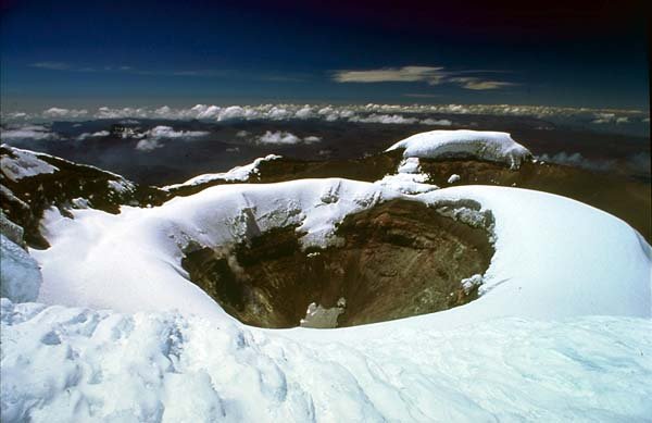
7.The most famous volcano of South America is Cotopaxi, located in the Andes, about 75 km (50 mi) south of Ecuador's capital, Quito, one of the highest active volcanoes in the world. It is the second highest in Ecuador, after Chimborazo (which is an inactive volcano). Cotopaxi rises from a highland plain of about 3,800 meters (12,500 ft), and has glaciers, even if located on the Equator, starting from 5,000 meters high (16,400 ft). There have been more than 50 eruptions of Cotopaxi since 1738, the last one in 1904.
During a war between the Incas and the Spaniards in 1534, the volcano erupted and put an end to the fighting as both fled from the battlefield. In the 1877 eruption pyroclastic flows descended all sides of the mountain, with lahars traveling more than 100 km into the Pacific Ocean and western Amazon basin draining the valley. The main danger of a huge eruption of Cotopaxi would be the flow of ice from its glacier and could affect 100,000 people and another eruption is imminent.
The capital of the Ecuador, Quito, is located close to Pichincha, a volcano located in the northwest side of the city.
8.Ojos del Salado (6,905 m or 23,016 ft) is a volcano located in the Andes on the Argentina-Chile border. It is the highest historically active volcano on earth, located in a remote and very dry region.
9.The volcanoes of Lesser Antilles are aligned along a curb marking the limits of three tectonic plates. In the subduction area, at depths of 5-10 km (3-6 mi), pouches of magma accumulate.
Mount Pel?e (French:"Bald Mountain") is the most famous active volcano in the Caribbean, located on the French Martinique island. It is the highest point in the island (1463 m or 4,876 ft).
Its eruption, in 1902, caused the worst volcanic disaster of the 20th Century, destroying the city of Saint-Pierre and killing about 26,000 to 36,000 people. The lake on its crater flowed as a hot mud torrent to the sea. The city was destroyed in 30 minutes by a cloud of hot matter, which came at the speed of 500 km (310 mi) per hour, at a temperature of 700-1058o C (which melted the glass). The volcano started to raise a pole of andezite lava, sometimes by 20 m (66 ft) per day, forming grooves and folds due to the intense friction with the walls of the walls of the craters. In the first months of 1903, the pole was 476 m (1,586 ft) tall and 100 m (333 ft) wide. The volcano ceased this eruption in 1905.
This blast brought to the attention of the public and governments the hazards and dangers of an active volcano. Only 2 people survived: an inmate and the guardian of the prison. Only 2-3 days after the disaster, when lava rivers and ash clouds were still flowing/falling, several ships could approach the harbor. Later, it was found that birds had deserted the area 3 weeks before the event. Migratory birds, using the island as a base, had skipped it. The reptiles had abandoned the area 2 days before. Dogs had barked restlessly, chickens, ducks and doves had refused to leave their kennels. Mount Pel?e could reawaken at any time, and before the 1902 eruption, it had been constantly active. It erupted again in 1929-1932.
10.The paradise of the Caribbean Montserrat Island, in the Lesser Antilles was destroyed in 1997 when the Soufriere Hills Volcano's eruption destroyed Plymouth, the island's two centuries old capital. Avalanches of hot rocks and gases, at 400o C, descended at speeds of 200 km (120 mi) per hour. Some of the rocks were as big as trucks and weighed tens of tonnes. The 1997 blasting buried most of the southern part of the island and killed 19 people. The volcanic chambers are separated.
The volcano started to be active in 1995 and since then, more than half of the 12,000 inhabitants of the island moved away. In 2007, a shot of ash cloud more than five miles (8 km) tall has been expelled by the volcano. A bigger explosion is expected soon, as the volcano's rising dome stayed in place after the recent one.
Other active volcano in the Caribbean is Saba (Mount Scenery: last blast in 1640).
11.The myth of the Atlantis, first mentioned by Plato 2400 years ago, could have been based on the pre-Greek Minoan civilization from Crete or Santorini. The huge eruption of the volcano of the Santorini island, 70 km (43 mi) north of Crete, was up to 10 times more powerful than the Krakatoa's eruption in 1883. Volcanic stones even reached the Egyptian shore of the Sinai peninsula and the eruption was heard over 3,000 miles (4,800 km) away. The eruption destroyed everything on an area of 150 km (92 mi). The Santorini's huge cone fell into the sea together with the western part of the island, provoking a big tsunami wave that flooded many islands in the Aegean Sea.
The stifling volcanic ash impeded for days the sunlight from reaching the eastern basin of the Mediterranean. About 80 cubic km of Santorini either blew up or fell into the sea, and all nearby life forms were erased. Still, the island has erupted 14 times between 198 BC and 1950. The 1659 eruption killed 70 people. The inhabited part of the island was devastated again in 1956 by a massive earthquake, and from time to time, the giant volcano spits smoke.
12.Auckland in New Zealand is located amongst 48 small volcanoes. The former volcanic depressions form two ports. The island Rangitoto, the closest to the port of Auckland, appeared 600 years ago from the water. At its emergence, a neighboring Maori village was buried in ash. The volcanic cone of Maugakiekie is located in the center of the city. The Auckland's volcanoes are covered by parks, sheep farms, sport courts, graveyards, and even houses, as many people prefer the panorama offered by the slopes of the volcanoes.
Whakaari/White Island is a volcano located situated 48 km (30 mi) from the east coast of the North Island of New Zealand, in the Bay of Plenty. It is New Zealand's only active marine volcano and perhaps the most accessible on earth. It rises to a height of 321 m (1070 ft) above sea level and 1,600 m (5,330 ft) from the sea bed.
13.There are 32 volcanoes in Iceland that have erupted in the historical times. Hekkla (1,491 m or 4,970 ft tall) is the most famous. In the '90s, it erupted 20 times! Vapors rose to height of 15 km (9 mi), being followed by lava rivers flowing by 1 m (3.3 ft) per minute. There were no victims, as the surrounding area is uninhabited.
Another famous volcano of Iceland is that on the island of Heimaey. It erupted on 23 January 1973. The lava flow threatened to destroy the harbor, the main source of livelihood for the 5,000 inhabitants of the island. However, by constantly spraying the lava with cold seawater, some of it solidified and diverted the rest, saving the harbor from destruction. The eruption destroyed half of the town, covering it with volcanic mud and ash.
14.Surtsey (Icelandic: "Surtur's island") formed a volcanic island off the southern coast of Iceland after an eruption that began 130 meters below sea level, and reached the surface on November 14, 1963. The eruption lasted until June 5, 1967, when the island reached its maximum size of 2.7 km?, but since then, it has been eroded by wind and waves to only 1.4 km? in size (with a rhythm of 10,000 square km yearly). Today the island harbors birds and seals colonies and in 2001, the Icelandic government submitted the island to be listed as a UNESCO World Heritage Site.
15.Europe's most known volcanoes are, of course, Mount Vesuvius and Etna. Mount Vesuvius (1,281 m) is located 9 km (6 mi) east of Naples, Italy. It is the only volcano on the European mainland to have erupted within historical times. It is best known for its eruption in AD 79 that led to the destruction of the Roman cities of Pompeii and Herculaneum. It has erupted many times since and today is regarded as one of the most dangerous volcanoes in the world because of the 3,000,000 people now living close to it and its tendency towards explosive eruptions. At least 300,000 of those living nearby would be killed by the next eruption if not evacuated beforehand.
Vesuvius was formed as a result of the collision of two tectonic plates, the African and the Eurasian. The former was pushed beneath the latter, deeper into the earth. Since 79, the volcano has erupted over 50 times, the last time in 1944, and none of the post-79 eruptions were as large or destructive as it. On occasions, the eruptions have been so large that the whole of southern Europe has been blanketed by ashes; in 472 and 1631, Vesuvian ashes fell on Constantinople (Istanbul), over 1,200 km away.
In 1631, it killed 4,000 people. Then the word "lava" started to be used, from Latin "labire" (to slip). The 1944 eruption covered in ash the nearby cities of Massa and San Sebastiano.
16.Mount Etna (from the Greek word aitho "to violently burn") is an active volcano on the east coast of Sicily, close to Messina and Catania. It is the largest active volcano in Europe, currently standing about 3,326 m (10,910 ft) high. Mount Etna is one of the most active volcanoes in the world (15 eruptions per century) and it is in an almost constant state of eruption. Its most destructive eruption during this time occurred in March 1669, when an estimated 830,000,000 m? of lava was ejected. The latest major eruption occurred on 2001 and the most recent in April, 2007.
17.The Italian triangle of active volcanoes is completed by Stromboli, in a small island in the Tyrrhenian Sea, off the north coast of Sicily. The island has a population of 400 to 750 and the volcano stands 924 m (3,031 feet) above sea level and over 2,000 m (6,500 ft) above the ocean floor.
18. Krakatoa is a volcano located on an island in the Sunda Strait between Java and Sumatra in Indonesia. The best known eruption culminated in a series of massive explosions on August 26-27, 1883, which generated the loudest sound historically reported: it was distinctly heard as far away as Perth in Australia (approx. 1930 miles or 3100 km), and the island of Rodrigues near Mauritius (approx. 3000 miles or 4800 km). Atmospheric shock waves reverberated around the world seven times and were detectable for five days. 36,417 were killed, mostly by the tsunamis which followed the explosion.
The eruption destroyed two thirds of the island of Krakatoa and eruptions of the volcano since 1927 have built a new island in the same location, called Anak Krakatau (child of Krakatoa). In the year following the eruption, average global temperatures fell by as much as 1.2 degrees Celsius. Weather patterns continued to be chaotic for years, and temperatures did not return to normal until 1888.
The 1883 eruption of Krakatoa is among the most violent volcanic events in modern times, equivalent to 200 megatons of TNT, about 13000 times the yield of the Little Boy bomb which devastated Hiroshima, Japan. Concussive air waves from the explosions traveled seven times around the world, and the sky was darkened for days afterwards.
Sea waves caused by the eruption were recorded as far away as the English Channel. The island is still active, with its most recent eruptive episode having begun in 1994.
The islands have turned a major case study of island biogeography and founder populations in an ecosystem being built from the ground up in an environment virtually sterilized.
Now although the weaker Anak Krakatoa, just 985-ft (300-m) tall, could still erupt, thousands of people live on the Mount Kelud (Java island), facing Krakatoa, as the rich volcanic soil makes them live in the shadow of the danger. In Indonesia, the best rice crops are obtained from the rich soils located close to the volcanoes.
19.The most violent volcano on Earth is considered Tambora (2,865 m or 9,550 ft tall) from the Sumbawa Island (Indonesia). On 10th of April 1815, the mount blew out into the atmosphere 1,250 m (4,160 ft) of its peak! The cataclism was marked with 7 of the VEI scale and killed at the moment 12,000 people. Subsequently 80,000 people died of hunger. About 150-180 cubic kilometers of debris were projected into the stratosphere, dimming the sky and depriving of summer the Northern Hemisphere.
20.But perhaps the most amazing Indonesian volcano is Kawah Ijen (2,600m or 8,660ft tall), the "Green Crater" from western Java, which has a lake made of 36 million cubic meters representing a solution of sulfuric acid and hydrogen chloride, the most powerful existing acids.
On the edges of the lake, the fumaroles (volcanic gas eruptions) depose 4 tonnes of sulfur daily. Such acid lakes are also found on the volcanoes Kusatsu-Shirane (Japan) and Poas (Costa Rica), but the Indonesian lake is by far the largest acid lake on Earth, having a maximum depth of 212m (706ft). These lakes result from the mix of rainfall water with gases coming from the depths of the volcano.
The walls of the Kawah Idjen lake are light ocher, but the water has a turquoise color, with emerald reflexes. The temperature of the water is of 34o C, and sulfur bubbles float on the surface. The surroundings are covered by a sulfur powder. The smell is pungent and irritating, filled with sulfur dioxide. From place to place, sulfur pours at a temperature of 120o C, like bright red trails, which gradually solidify, turning lemon yellow. The lake contains 600,000 tonnes of hydrogen chloride, 550,000 tonnes of sulfuric acid, 200,000 tonnes of aluminium sulphate and 170,000 tonnes of iron sulphate.
People from the neighboring area extract sulfur from the crater manually. Each worker can transport 40 to 70kg (90 to 155 pounds) at once on the abrupt slopes of the volcano, using bamboo ladders where the slope is too steep. In one day, a man can carry up to 360 kg (750 pounds) of sulfur. The daily production of the exploitation is just of 4 tonnes, a derisory quantity, if we consider the fact that the crater harbors 30,000 tonnes of sulfur. Industrial exploitation of the lake has not been planned so far, as the volcano erupts from time to time, projecting acid to the height of 600 m (2,000 ft) and splashing the neighboring areas with a corrosive rain.
In 1976, 50 people were surprised inside the crater by an enormous bubble of sulfuric dioxide, which, after raising the surface of the lake, killed 11 of them by asphyxiation. The local people said it was the sacrifice asked by the volcano for offering its riches.
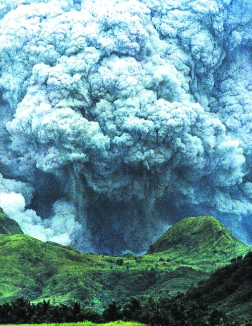
21.Mount Pinatubo is an active stratovolcano located on the island of Luzon (Philippines). Before 1991, the mountain was inconspicuous and heavily eroded, covered by dense forests which supported a population of several thousand indigenous people, the Aeta, who had fled to the mountains from the lowlands when the Spanish conquered the Philippines in 1565.
The volcano's eruption in June 1991 came after 635 years of dormancy, and produced the second largest terrestrial eruption of the 20th century. The effects of the eruption were felt worldwide. It ejected roughly 10 billion metric tons of magma, and 20 million tons of SO2, bringing vast quantities of minerals and metals to the surface environment. It injected large amounts of aerosols into the stratosphere-more than any eruption since that of Krakatoa in 1883. Global temperatures dropped by about 0.5?C (0.9?F), and ozone destruction increased substantially.
22.Still, the most active volcano of the Philippines is Mayon (2,462 m or 8,206 ft tall), from the southeastern part of Luzon.
23.Piton de la Fournaise is the most active ground volcano of the Indian Ocean, located in Reunion Island. It has an age of 530,000 years and has erupted 100 times in the last 3 centuries.
24.In Oceania, the most famous volcano is Mauna Loa ("Long Mountain") from the Island of Hawaii. It is Earth's largest volcano, with a volume estimated at approximately 18,000 cubic miles (75,000 km?), although its peak is about 36 m (120 ft) lower than that of its neighbor, Mauna Kea. Its height is of 9,000 m (30,000 ft) from the sea bed, but only 4,170 m (13,900 ft) stay above the sea level, having a diameter of 100 km (60 mi) at level 0.
Lava eruptions from Mauna Loa are very fluid and the volcano has extremely shallow slopes as a result. The volcano has probably been erupting for at least 700,000 years and may have emerged from the sea about 400,000 years ago, although the oldest known dated rocks do not extend beyond 200,000 years. Mauna Loa's most recent eruption lasted from March 24, 1984 to April 15, 1984.
25.Kilauea of Hawaii, 1,222 m or 4,073 ft tall, is the most active volcano in the Earth. It has caused 74 long eruptions since 1794. The volcano has been erupting continuously since 1983.
26.Beside these volcanoes, there are three non active ones with a great impact on human culture. Mount Ararat (5,165 m) is the tallest peak in Turkey. The snow-capped, dormant volcanic cone is located 16 km west of the Iranian and 32 km south of the Armenian border and is the place were Abrahamic religions say Noah landed after the flood. The last activity on the mountain was a major earthquake in July 1840 centered on the Ahora Gorge, a northeast trending chasm that drops 1,825 meters (6,000 ft) from the top of the mountain.
27.Kilimanjaro (5,895 m) located north-east, is a dormant volcano representing the tallest free-standing mountain rise in the world, 4600 meters (15,000 ft) from the base, and Africa's tallest height. There are fears the volcano may collapse, causing a major eruption similar to the 1980 eruption of Mount St. Helens. The mountain is covered by an ice cap, harboring some of the few equatorial glaciers.
25.There are about 200 volcanoes in Japan, of which 70 are active. The most famous is Fujiyama. Mount Fuji (3,776 m) is the highest mountain in Japan, located near the Pacific coast of central Honsh?. It is a well-known symbol of Japan and is frequently depicted in art and photographs, as well as visited by sightseers and climbers. The volcano is still considered active, but eruption risk is low, and the last recorded eruption occurred in 1708.
From July to September, this is a pilgrimage site, visited by millions of people. People dressed in traditional clothes wear a mini-model of Fujiyama, raised over their heads, and at night, tens of braided straw cones, braided along the roads, are fired. This ceremony evokes the 1708 eruption.
28.Usu, from the island of Hokkaido, is the most active Japanese volcano. At each eruption, the underground magma rises, forming amazing mounds, from a few tens to a few hundreds of meters tall, called cryptodomes. The cryptodomes form in the top of the volcano, in the middle of the fields and even inside human settlements. Unlike volcanic cones, made of the accumulation of products expelled though the mouth of the active volcanoes, the cryptodomes are made of old volcanic deposits, pushed up and deformed by the profound magma, which does not necessarily pierce to the surface. The Usu volcano experienced three eruptions of this type during the 20th century, in 1910, 1943-1945 and 1977-1978.
The 1943-1945 eruption formed the Showa-Shinzan ("The new mountain of the Showa Era"), 300 m (1,000 ft) tall. Today, about one million people visit the volcano annually.
29.Sakurajima is located on an island off Kyushu. Its highest peak is 1,117 m (3,723 ft) tall. In 1914, a great eruption occurred, burying the straits with lava, thus connecting the former island to the Osumi Peninsula, so that Sakurajima is no longer an island. The 1914 eruption has been the most powerful in Japan during the 20th century. 30.Galeras (Urcunina among the indigenous people) is a volcano in Colombia, near the city of Pasto, located at an altitude of 4,276 m (14,029 ft) above sea level. It has erupted frequently since the Spanish conquest. The 1993 eruption killed nine people.
This volcano is the richest in the world! Its lava contains 220 grams of gold per tonne (gold mines may have just 30 gram per tonne!). The volcanic gas, too, contains molten gold, which via cooling is deposed on the walls of the crater. In 10,000 years of activity, Galeras brings to the surface 200 tonnes of gold. In fact, many gold mines are former volcanoes (like in California).
Another Colombian volcanoes are not that beneficial: The eruption in 1985 of the volcano Nevado del Ruiz (Columbia) made 21,000 victims, killed by the torrents of volcanic mud that swallowed the city of Armero.
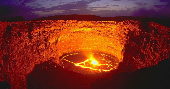
31.This is like a wound that never gets closed. In one of the hottest spots of the Earth, in the desert of northern Ethiopia, where even in the winter temperatures vary between 40 to 50oC, the volcano Erta Ale is active for hundreds of years.
Most volcanoes manifest through occasional eruptions, then their lava hardens, like a crust on a wound. But the wound of Erta Ales does not get closed. 25 Ma ago, a crack emerged between the Arabian and the Ethiopian plates. Even today, the plates move apart one from the other with 0.5cm (0.2in) annually. The fracture formed the Red Sea and the Great African Rift. The only other volcanoes known to have a lake of continuously boiling lava are Puuoo in Hawaii and Erebus in Antarctica.
The depth from the edges of the crater to the lake of boiling lava is of 100m (330ft). The molten lava has a temperature of 1,100-1,200oC. Visitors can approach to 2m (6.6ft) off the lake, as the hot air has the tendency to rise, being replaced by the cold air (of 40-50oC...). At 2m off the edges of the lake, there is a wall of warmth having a temperature of several hundreds degrees Celsius.
Along the years, this volcano swells its lava lake before retracting it back. Still, from time to time, the lava overflows the edges of the crater, like in 1974. This dynamic shows that the lake is placed close to the magma reservoir that directly fuels the eruption of a volcano. In some parts of Ethiopia, the lava accumulations are 2,000 m (6,600 ft) thick, one of the largest in the world.
32.The most active African volcano is Mount Nyamuragira in the Virunga Mountains of the Democratic Republic of the Congo, located 25 km (16 mi) north of Lake Kivu. It has erupted over 30 times since 1880. Nyamuragira is located only 13 (8 mi) km north-north-west of Nyiragongo, the volcano which caused extensive damage to the city of Goma in its 2002 eruption.
33.On the night of August 21st, 1986, 80 million cubic meters of carbon dioxide (1.6 million tonnes of CO2) burst from the water of the volcanic Lake Nyos (northern Cameroon), killing by asphyxiation 1,700 persons and 3,600 livestock. The 50 m (166 ft) tall jet was made of gas (90%) and water. The gas had accumulated in the depths of the lake, coming from the magma below, dissolved in the water due to the high pressure exerted at 100-200 m (330-660 ft). The cause of the burst is unknown; it could have been due to a sudden raise of the water or an earthquake. A similar case had been signaled 2 years before at Lake Monoun, 100 km (62 mi) away of Nyos, killing 37 people. The only other lake in the world, besides these two, known to manifest a similar phenomenon is Lake Kivu (Rwanda).
After that, the lake started to reload itself, the gas amount approaching the saturation limit, when no intervention can be made without the risk of an explosion. By 2001, the concentration reached the value of 10 liters of gas at one liter of water, the limit being of 14 liters of gas at one liter of water. On January30, 2001, a long operation of draining the killer lake started. The gear degases at a rhythm of 20 million cubic meters of gas annually. But the lake has large reserves of gas, about 300 million cubic meters, its refilling being made with 2-5 million cubic meter per year. The installed column, which will lose efficiency in time, will require 30-50 years to make the lake really non-dangerous. Another 3-4 columns would reduce the task to 4-5 years.