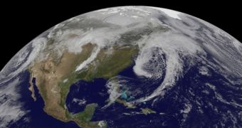
Images collected by the US National Oceanic and Atmospheric Administration's (NOAA) GOES-13 and GOES-15 satellites on Monday, March 31, reveal the presence of three dragon-like, low-pressure atmospheric fronts over the United States, stretching from the northern reaches of the East Coast, over the Great Lakes area, to the Pacific Northwest.
Due to their distinctive, signature comma-like shape, these atmospheric features resemble three dragons coiled over North America. Scientists with the US National Weather Service (NWS) say that the westernmost front will likely bring rainfall and snowfall to the western portions of Washington state over the next few days.
The feature currently above the western Atlantic Ocean will likely bring heavy rain and snow over parts of New England, while the third one, currently hovering over Nebraska, will do the same for areas stretching from southern Minnesota to eastern Texas. The image above was collected by GOES-13 (or GOES-East) at 17:45 UTC on Monday, and processed at the Goddard Space Flight Center (GSFC).
The satellite is located in a geostationary orbit that enables it to capture optical and infrared images of weather covering areas in the eastern US and over the Atlantic Ocean. GOES-15 does the same for the western parts of the country. Images from the two spacecraft can be easily assembled via the NASA/NOAA GOES Project, which is being managed by experts at GSFC in Greenbelt, Maryland.

 14 DAY TRIAL //