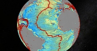
A recent paper in the journal Science announces the discovery of thousands of previously undocumented mountains on the global seafloor.
As explained by the specialists behind this research project, such geological formations are known as seamounts.
Scientists with the University of California – San Diego and colleagues explain that they found these thousands of previously uncharted seamounts while working on piecing together a brand new map of the world's seafloor.
This map was put together using data provided by the European Space Agency's CryoSat-2 satellite and NASA's Jason-1 satellite and is said to be twice as accurate as the previous version, which dates back to about 20 years ago.
Using satellites to map the global seafloor
As part of this research project, scientists compiled and analyzed information concerning the behavior of radar signals or lasers hitting sea and ocean surfaces and then bouncing off them. The focus was on how long it took for these signals to return to the satellite that produced them.
According to previous investigations, underwater volcanoes and mountains cause the sea surface to form a slight bulge. Trenches, on the other hand, cause it to sag. This happens because appearance of the sea surface responds to and mirrors shifts in our planet's gravity.
Hence, by studying the global sea-surface topography, specialists can make educated guesses about what the bottom of seas and oceans looks like. What's more, they can gain a better understanding of the tectonics of the deep oceans.
“The team has developed and proved a powerful new tool for high-resolution exploration of regional seafloor structure and geophysical processes,” researcher Don Rice said in a statement. “This capability will allow us to revisit unsolved questions and to pinpoint where to focus future exploratory work,” he added.
Mapping more than uncharted seamounts
The University of California – San Diego specialists and fellow researchers say that, apart from revealing the presence of thousands of previously unknown seamounts on the world's seafloor, the satellites mapped earthquakes and unseen continental connections across South America and Africa.
Besides, they made it possible for the scientists to reach a better understanding of the behavior of massive oceanic plates and how their moving about influences the appearance of rifts, ridges, trenches, and other geological formations at the bottom of our planet's seas and oceans.
Commenting on the importance of this research project, the specialists wished to draw attention to the fact that “One of the most important uses of this new marine gravity field will be to improve the estimates of seafloor depth in the 80 percent of the oceans that remains uncharted or is buried beneath thick sediment.”

 14 DAY TRIAL //