 14 DAY TRIAL //
 Of the seven continents, Antarctica detains some superlatives: it is the coldest ground (the record: - 94.5Oc), the driest (20 mm annually), the most remote and the highest (average height of 2450 m).
It has the highest atmospheric pressure (1156 mb) and experiences the strongest winds (60 m/s).
Its surface is estimated at 14,200,000 square kilometers, a tenth of the Earth's ground.
Many believe that Antarctica is in fact a large group of islands, and not a sole continuous continent, but this is hard to see as just 1 % of the continent's surface (140,000 square kilometers) is free of ice and those islands would be bound by thick ice pack.
The rest is covered by an ice pack 2 to 3,000 m (6 to 10,000 feet) thick, the average being 2200 m.
Antarctica's ice has a volume of 29.46 million cubic kilometers and represents 90 % of the freshwater reserve of the planet.
Modern technology revealed several freshwater lakes under the ice pack, the largest being 150 km (95 miles) long, formed through the melting of the lower part of the ice due to the heat from the deep Earth.
The so-called summer lasts only two months and meanwhile, in the most sheltered places, a scarce vegetation develops, mainly likens.
The shore's average annual temperature is -10 - -20o C.
Eastern Antarctica, situated in the Eastern Hemisphere, is a huge oval zone with a 10,433,000 square kilometers surface, while the Western Antarctica (Lesser Antarctica) with a 3,532,000 square kilometers has alpine peaks connected with alpine chains in South America, that's why they are called the Antarctic Andes.
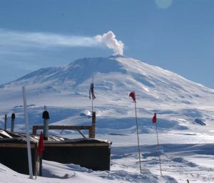
Here is the only active volcano of the continent, Erebus, located on Ross Island.
The highest peak in Antarctica is "Committee Range", 6096 m.
The geographic South Pole is located at a 2804 m altitude.
Antarctica is also the richest place on Earth where meteorite fragments have been found.
Geological structures found in Antarctica are similar with some found in Africa, Australia, enhancing the theory that these continents, together with South America and India were once part of a southern supercontinent called Gondwana.
A marsupial fossil proved that marsupials entered Australia from South America using Antarctica as a land bridge.
Fossilized crocodiles, plesiosaurs (a type of large long necked marine reptiles from dinosaur era) and wood point that 70 million years ago, during the dinosaur era, this was a tropical heaven.
Drilling in the zone of the Ross Sea indicated hydrocarbons' presence.
Geophysicians estimate Antarctica's deposits at 45 billion oil barrels.
Geological data shows that Antarctica possesses the largest carboniferous basin in the world.
The Transantarctic Mountains contain along their length (over 3,000 km (1800 miles)) high quality carbons.
Carbon was also found in the Prince Charles Mountains.
In the Prince Charles Mountains, Mac Robertson Land, Dronning Maud Land iron ore was found.
Also, zinc, lead, gold, silver, molibdenum, nickel, crom, cobalt and uranium ores were discovered.