14 DAY TRIAL //
 Meteorological systems are continuously moving air masses, with diameters of 150-4,000 km (92-2,500 mi). Some are 12-15 km (7.5-9.2 mi) deep, located in the troposphere (the lower layer of the atmosphere). Those that are 1-3 km (0.6-1.8 mi) deep are faster. The meteorological systems are defined by their variations in atmospheric pressure and surrounding winds.
The main meteorological systems are anticyclones (regions of high pressure, in which the air movement is oriented downward) and cyclones (areas of low pressure, where the air masses rise). Clouds form where the air rises. That's why low pressure areas are connected to cloudy, rainy or stormy weather.
Anticyclones have instable weather that lasts for several days. In the Northern Hemisphere, anticyclone winds blow in the direction of the clock hands, and in the Southern Hemisphere they have the opposite direction. On meteorological maps, anticyclones are marked through a series of concentric isobars (lines uniting regions with the same atmosphere pressures).
In anticyclone area, a weak wind blows and the sky is serene. Without the clouds, the heat emanated by Earth's surface rises in the cosmic space, that's why the soil and the air above cool rapidly during the night. During the winter, this often brings the freezing or, in wet air, fog. The weak winds favor these phenomena. A stronger wind would mix the air, and the cooling at the ground level would rise higher.
Anticyclones can form in cold areas inclusively. In these places the air is heavier, that's why the pressure close to the ground is higher. This type of anticyclones form during the winter in Central Canada and Siberia. They are usually narrow, no more than 3 km (1.9 mi).
Around the tropics (20-30o N and S), huge anticyclones form. These air masses are deeper and more stable. Here, the air risen because of the hot tropical sun descends to the surface of the Earth because of the high atmospheric pressure. In these areas the hot deserts of the world, like Sahara, are located.
From the tropical anticyclones, the trade winds blow to the Equator, and the western warm winds blow towards the Poles. West winds encounter the east winds blowing from the cold polar areas in a frontal area. Along these fronts the cyclones form. The cyclones bring unstable weather and storms over the central latitudes.
The frontal zone is not a right line. Along the front, sinuosities can appear due to the cold winds blowing towards the Equator and hot winds blowing towards the Poles. These movements cause turbulences (twirling movements), whose effect is accentuated by the strong jet streams, winds blowing at the upper limit of the atmosphere. In depression areas, winds blow in opposite direction to the anticyclone winds: counterclockwise in the Northern Hemisphere and clockwise in the Southern Hemisphere. On meteorological maps, depression zones are represented as concentric isobars, the atmosphere pressure being lower in the center.
Warm air and cold air do not mix easily. Warm air advances as waves in a front and does not mix with the cold, dense air, but it raises over it. The warm air is replaced by cold air, forming the depression zone. The depression zone has two fronts: the warm front delimits the approaching warm air masses from the masses of cold air on the surface. Here, the warm air rises over the cold air. The water vapors in the rising air cool gradually, condensate and form clouds. Immediately after the warm front, the cold front is found. Along the cold front, the cold air penetrates under the warm air, making it rise. That's why the cold front is cloudy and rainy. The cold front moves more rapidly than the warm front, and when a cold front meets a warm front, the warm air is pushed above the cold air. The phenomenon is called occlusion. When the occlusion takes place, the decrease of the atmosphere pressure ceases soon.
The emergence of a hazy cirrus cloud at high altitude usually forecasts a pressure drop. Subsequently, a thicker cloud will emerge at an average altitude; this is an altostratus cloud. At a lower altitude, a rain cloud (nimbostratus) appears. These clouds bring a persistent rain, of several hours, before the passing of a warm front.
Following a hot front, the warmth comes in a cloudy, humid zone. They are followed by the cold front, bringing showers, because of the ascend of the air masses. Along a cold front, abundant rains are frequent, but they do not last much, like those from the warm front. After the passing of the cold front, weather is serene and cool.
Except the polar areas, storms can be found everywhere in the world. Annually, about 2,000 storms occur around the Globe.
Many storms form along the cold fronts, on the whirls of the rapidly ascending warm and wet air, forming dark storm clouds (cumulonimbus) that rise over the cold front and move with 30 km (19 mi) per hour. Because of the heat of the soil and of the inferior air layers, tropical storms are the most violent ones. In these areas, in just one day, 600 mm of water can fall. Storms caused by the heated soil can also form in the temperate areas during the hot summer days, especially in the later afternoon.
Along the Equator, turbulent groups of clouds form when the heat and humidity rise in the upper layers. Sometimes, groups can join one another, getting away of the Equator and produce violent tropical cyclones, called hurricanes, typhoons or willy-willy, depending on the area.
Hurricanes are much larger than normal storms. In fact, storms can be parts of the hurricanes. Their diameter can vary from 200 to 500 km (125-312 mi). The center is a quiet hotbed, with an ascendant atmospheric movement. In this area, the sky is serene and the air is calm. But around the hotbed, the air rises rapidly, aspiring humidity, and forming the extremely violent systems of clouds and whirls. The wind speed overcomes 119 km (75 mi) per hour, even reaching 300 km (190 mi) per hour.
In 1970, a hurricane killed about 1 million people in Bangladesh and India (West Bengal).
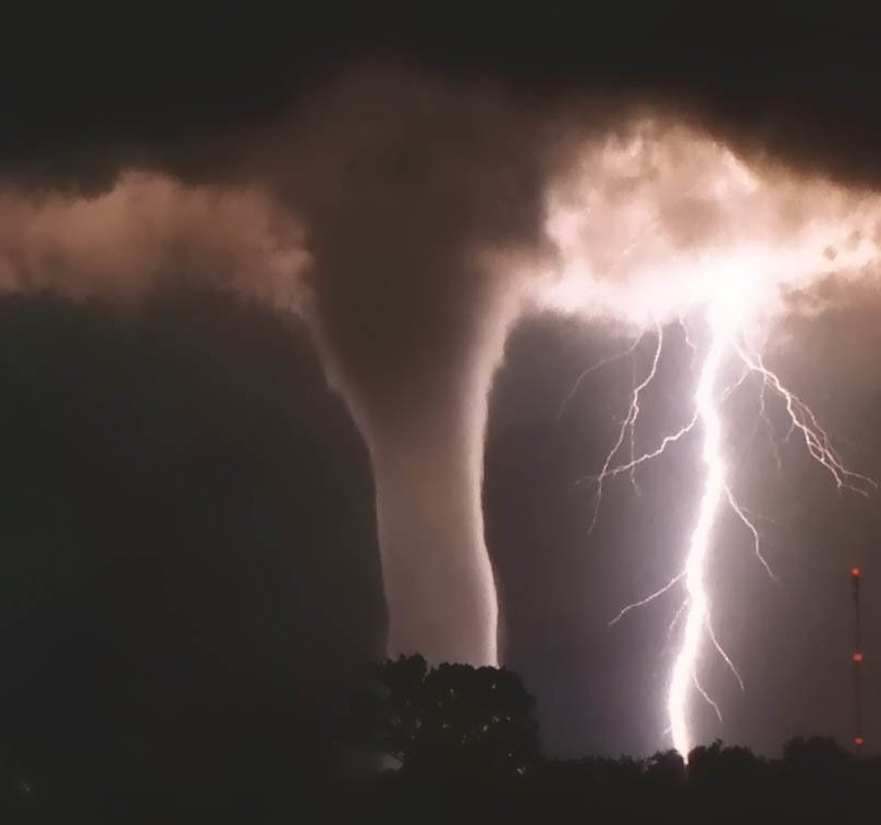
The tornadoes are smaller storms (their diameter is of several hundreds of meters) but the most destructive of all types of storms. In US, tornadoes are called also twisters, being funnel-shaped air whirls. The wind in the "funnels" has a speed of over 300 km per hour. The rapidest speed inside a tornado was of 450 km (280 mi) per hour; it was measured in Wichita Falls, Texas, in 1958. The tornadoes last just about one hour, advancing on the ground with a speed of 10 km (6 mi) to 560 km (350 mi) per hour. They produce enormous damages and are frequent in US and Australia. In the center of US, about 500-600 tornadoes occur annually.
The origin of the tornadoes is unknown. They are often accompanied by storms. The air pressure inside the tornado is low; the low pressure of the tornadoes and the high pressure of the building make the latter simply explode. In 1989, a tornado killed 1,300 people in Bangladesh.
Air whirls are much rarer than tornadoes and can emerge even on sunny weather. The air rises and starts spinning around. Sometimes, it takes with it dust, straw, garbage which make it visible. In hot deserts, the air whirls raise sand.
The most famous rain bringing wind is the monsoon. It is encountered in places where there are significant differences between the summer pressure and winter pressure, like in India. During the winter, an enormous anticyclone forms above the Asia. From this anticyclone, an east wind blows, determining a dry and relatively cool weather in India. During the spring, the land starts to heat and a huge air mass with low pressure develops over the Tibetan Plateau and Afghanistan. From the Indian Ocean, a wet air mass will enter this system of low pressure. These air currents will produce the southwest winds, which cause powerful rains in India each summer.