Australia is the lowest and flattest continent. Some mountains punctuate its relief, but they could be seen as mere hills in other areas. For example, the highest Australian peak is Kosciusko (New South Wales): 2,230 m (7,430 ft) tall.Yet, they attract mountaineering amateurs and, during the winter, they are the only snowed places on the continent where people can ski.
Grampians Mountains are located in western Victoria, in the southwest extremity of the Great Dividing Range, which starts from Cape York Peninsula, in northeast, descending along the eastern coast of the continent.
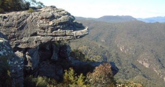
The Grampians Mountains are made of 3 main ranges and several smaller formations, stretching north-south, on a length of 100 km (62 mi) and a width of 55 km (34 mi). The tallest peak of the Grampians is William, 1,166 m (3,890 ft).
These mountains started to form 395 Ma ago. For 50 Ma, enormous amounts of sand sedimented on the bottom of a great lake, compacting and making huge masses of alternative layers, of hard quartzes and softer sediments, with a thickness of about 600 m (2,000 ft). Erosion and folding led, in time, to the creation of the formations that make the greatness and beauty of the modern mountains.
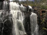
Wonderland Range is 6.5 km (4 mi) long and very narrow, hosting a profound pass called the Great Canyon. Another pass, Silent Street, has monolith walls which rise vertically, being pierced by plants from place to place (resembling the eyes of a window), the ground being paved by slabs, like a street. The series of 4 cascades from the MacKenzie pass is the most spectacular.
The Grampians maintain a clime similar to that of Ice Age Australia, where many relict species of plants and animals survive. 20 plant species are endemic. Over 1,000 species of plants live in these mountains (over 100 are orchids) and the fauna comprises kangaroos, koala, bandicoots, echidna, platypus, various reptiles and about 200 species of birds.
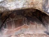
Before the arrival of the White man, the local aboriginal tribes named the Grampians Cowa, Naram Naram and Tuuwull, translated through "abrupt hills" or "abrupt hillocks". Over 40 sites with wall paintings, executed over the tall rocks of the mountains, have been found. The paintings belong to two distinct styles. A primitive form, made in red limonite, was practiced by the Buandik tribe, while a recent form, from the middle of the 19th century and made with white clay, was proper to the Jardwa tribe. Aboriginal sanctuaries and ceremonial points were found in the Grampians as well.
The first European to step on the Grampians was Thomas Mitchell, in 1836, and he named the mountains from the Grampians of his native Scotland. By 1840, cattle breeding started in the area. By the middle of the 19th century, the gold rush attracted 20,000 settlers in this region, as a consequence of the finding of gold nuggets at Pleasant Creek. The forests of the Grampians provided with wood for the mines and settlements.
The stone of the Grampians was used for erecting monumental buildings, like that of the Parliament, Mayoralty and Post Office, in Melbourne. A reservoir system built in the Grampians is one of the largest in the world, with a total capacity of 760,000 megaliters, delivering, via canals, water for 50 settlements and 7,000 farms, on an area of 28,000 square km (11,000 square mi). 150,000 hectares in the region form the Grampians National Park. The park is crossed by 100 km (60 mi) of main roads, 1,000 km (600 mi) of secondary paths and has 50 points for picnic.

 14 DAY TRIAL //

