14 DAY TRIAL //
 On April 25, Nepal experienced a devastating 7.8-magnitude earthquake. Experts with the US Geological Survey say that the shake struck less than 80 kilometers (50 miles) northwest of Kathmandu, the country's capital city, at a depth of just 15 kilometers (9 miles).
Over 5,000 people have so far been confirmed dead. As search and rescue missions are still ongoing, it is believed the death toll will eventually add up to 10,000.
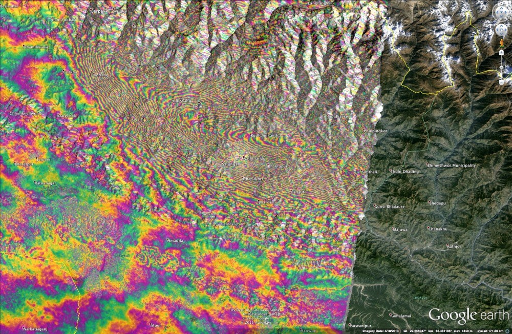
Just yesterday, researchers with the European Space Agency released satellite images documenting the earthquake's impact on local landscapes. The images, delivered by the Sentinel-1A radar satellite, explain why the shake was so severe and claimed so many lives.
The shake lifted the ground near Kathmandu
The 7.8-magnitude earthquake that hit Nepal this past April 25 happened when the ground gave out and ruptured along the region where the crustal plate carrying India meets and dives under the one supporting Asia, geologists explain.
Having compared before-and-after radar images of the affected area, researchers with the European Space Agency found that, during the shake, a patch of land measuring about 120 kilometers (75 miles) in length and 50 kilometers (30 miles) in width was pushed upwards.
The view delivered by the Sentinel-1A satellite puts this sudden elevation at about 1 meter (3 feet). Since this region that was forced upwards is located not far from Kathmandu, this explains why the city suffered extensive damage.
“Radar imagery from the Sentinel-1A satellite shows that the maximum land deformation is only 17 kilometers [10.5 miles] from Nepal’s capital, Kathmandu, which explains the extremely high damage experienced in this area,” European Space Agency experts explained in a statement.
Mount Everest, on the other hand, shrunk
Specialists say that, while the land around Kathmandu was pushed upwards during the 7.8-magnitude earthquake, the ground further north from Nepal's capital city descended. This happened because, in this region, the planet's crust relaxed.
It is believed that, as a result of this relaxation, tall peaks in the Himalayas, Mount Everest included, shrank to a certain extent. More precisely, geologists estimate that Mount Everest and its siblings each lost about 2.5 centimeters (1 inch) in height.
As severe as this latest earthquake that hit Nepal was, experts have reasons to believe that it failed to release all the seismic stress built up in the ground. Hence, it is possible that an even more severe shake will happen in the region in the near future.