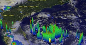
This past July 1, the National Hurricane Center in the United States announced the formation of the first named storm of this year's Atlantic hurricane season.
Following the formation of Tropical Storm Arthur, the National Hurricane Center warned that folks living on the east coast of Florida might want to keep an eye open for heavy rains on Tuesday and Wednesday.
What's more, Live Science tells us that, according to data at hand, it is possible that this first named storm of the 2014 Atlantic Hurricane Season will turn into a category-one hurricane by 2 a.m. ET on July 4.
For the time being, it is unclear whether the storm will hit the Carolina coastline in a couple of days or will instead remain offshore and merely wave at people as it passes by.
Should it become a category-one hurricane, Tropical Storm Arthur will pack fairly strong winds whose speed will be one of about 74 miles per hour (approximately 119 kilometers per hour).
Hence, specialists with the National Hurricane Center say that, all things considered, people living on the United States East Coast should expect a not-so-pleasant 4th of July, at least not as far as the weather is concerned.

 14 DAY TRIAL //