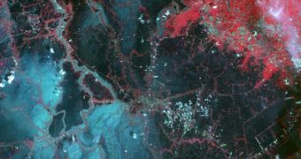
The Advanced Spaceborne Thermal Emission and Reflection Radiometer (ASTER) instrument aboard the NASA Terra spacecraft captured this view of catastrophic floods affecting Thailand on October 23. The catastrophe was caused by heavy monsoon rains that have been pouring since this July.
Even the capital city of Bangkok is threatened by the engorged waters of the Ayutthaya River, and authorities are currently scrambling to adopt measures that would safeguard the city. However, the best thing that can happen is for the rain to stop.
This ASTER view of the floods covers an area of 35.2 by 66.3 miles (56.7 by 106.9 kilometers), and displays vegetation in red. Flood water is shown in both black and dark blue, while brighter shades of blue represent sediment-laden waters.
ASTER operates in 14 spectral bands, which span from visible-light to the thermal infrared portions of the electromagnetic spectrum. The instrument has a spatial resolution of 15 to 90 meters (about 50 to 300 feet).

 14 DAY TRIAL //