Volcano eruptions are great no matter where you see them from. Well, assuming that you're not actually caught by one. But perhaps the best way to understand just how massive these events are is to see them from above.
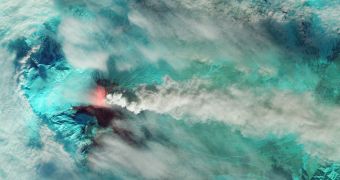
NASA's Landsat 8 captured some stunning images of the Klyuchevskaya volcano in the Kamchatka Peninsula. It's one of the most active volcanoes on Earth, so the fact that it's erupting isn't that surprising.
In fact, it's been doing that since August, though the activity has ramped up this month.
"The Kamchatka Volcanic Eruption Response Team (KVERT) reported a thick plume of ash and Steam streaming from the summit on October 11. Subsequent days brought explosive eruptions, lava fountains, and volcanic tremors," NASA explained.
"At times, the ash plume rose from the summit (elevation 5 kilometers, or 16,000 feet) up to 7.5 to 10 kilometers (24,000 to 32,000 feet)," it added.
The image you see above was captured on October 20. The colors aren't natural; they've been used to emphasize the different regions. Clouds, ash, and steam are grey while the snow and ice are colored green.

 14 DAY TRIAL //
