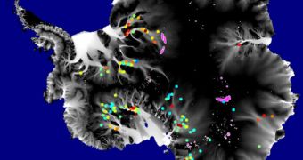
As years of satellite observations in the Antarctic went by, NASA experts observed that the southern continent had, in fact, a very well developed “plumbing system” underneath its miles of ice. Underground lakes, pressured by the tons of ice above, have created thin water layers between the rocks and the sheets, and also an extensive cavity system, which allows for draining and resupplying neighboring lakes, near and far away. Understanding these hidden systems is very important for future studies and predictions on the faith of the ices in the remote region.
“Even though Antarctica's ice sheet looks static, the more we watch it, the more we see there is activity going on there all the time,” the leader of a new study, University of Washington in Seattle expert Benjamin Smith, says. He argues that the thin layers of water cause the glaciers to break free from their rocky support, and push them into the ocean. If many of them break, then they can significantly affect the sea levels around the world, endangering people living in large metropolises and urban centers such as New York, Tokyo, London and Rotterdam.
In their new research, experts led by Smith analyzed the changes that had occurred in the Antarctic over the last 4.5 years, using data recorded by NASA's Ice, Cloud and land Elevation satellite (ICESat). They looked at the previously identified locations of some 124 active lakes, and tried to analyze the influence that the formations exerted on the ice sheets above. The results of their research are detailed in the latest issue of the Journal of Glaciology, a press release on NASA's official website shows.
Two decades ago, in the early 1990s, airplane-mounted lasers were the only method scientists had of looking at what lay beneath the ices. But ICESat's Geoscience Laser Altimeter System allowed geophysicist Helen Fricker, from the Scripps Institution of Oceanography, La Jolla, California, to start detecting the boundaries of the continent beneath the ice sheets from low-Earth orbit. In order to determine the actual spread of the continent, she needed to differentiate ground-based ice from floating sheets. By measuring the differences over the years, she managed to obtain a map of how elevations changed, a phenomenon mostly driven by underground lakes.
“Sub-ice-sheet hydrology is a whole new field that opened up through the discovery of lakes filling and draining on relatively short timescales and involving large volumes of water. ICESat gets the credit for enabling that discovery,” NASA Goddard Space Flight Center glaciologist Robert Bindschadler says. He has also contributed to other studies of the Antarctic, which relied on the same satellite data. “The survey identified quite a few more subglacial lakes, but the locations are the intriguing part. The survey shows that most active subglacial lakes are located where the ice is moving fast, which implies a relationship,” he adds.
“Most places we looked show something happening on short timescales. It turns out that those are fairly typical examples of things that go on under the ice sheet and are happening all the time all over Antarctica,” Smith concludes.
A conceptual animation of the new study can be viewed here.

 14 DAY TRIAL //