A group of experts at the MacDonald, Dettweiler & Associates (MDA) Corporation recently reprogrammed the radar instruments aboard the Canadian Radarsat-2 spacecraft so that the instrument collects the same type of data as the upcoming radar instrument on the European Space Agency's (ESA) Sentinel-1A satellite will.
The spacecraft is currently scheduled to launch into space on April 3 aboard a Soyuz-STA medium-lift delivery system sporting a Fregat upper stage. Takeoff will occur from the Soyuz Launch Complex at the ESA Kourou Spaceport, in French Guiana, South America, at 21:02 UTC. The satellite will be inserted into a geocentric Sun-synchronous orbit, at an altitude of 693 kilometers (431 miles).
Sentinel-1A will be the first Sentinel-class satellite to launch as part of the ESA Copernicus program. Its most important instrument is an advanced radar capable of mapping ice flows across glaciers and ice sheets, as well as monitor land subsidence. This C-band Synthetic Aperture Radar (SAR) will be able to operate regardless of weather conditions and will collect data at all times, including at night.
The satellite is designed in such a way that it will be capable of rapid repositioning, allowing operators to use it as a rapid response tool when natural disasters such as floods and earthquakes occur. One of the most important applications for the spacecraft will be to monitor shipping lanes around the world, providing commanders with information on wind and wave patterns, and so on.
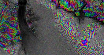
Another important application for Sentinel-1A will be to monitor glacier flows in ice sheets around the world. This task will be performed at unprecedented levels of accuracy, as demonstrated by Radarsat-2 during its recent observations session. The Canadian spacecraft was used to image the Petermann Glacier in northwestern Greenland and was able to reveal areas that flow faster than others.
The photo of Petermann Glacier above was stitched together from two photographs Radarsat-2 collected 24 days apart. Even the minutest differences in ice motions are revealed, and this feat is accomplished with a lesser version of the instrument that will fly on Sentinel-1A. An “interferometric” wide-swath mode technique is the foundation for the European spacecraft's radar.
The test instrument was also able to detect surface subsidence in Mexico City, after collecting a series of 11 images over several days. This data product is also indicative of the type of performances the C-band SAR on Sentinel-1A will be able to achieve once it launches.
In 2015, the ESA spacecraft will be joined in orbit by its twin, Sentinel-1B, which will provide operators with the ability to keep an eye on many more targets at once. Additional sets of satellites are scheduled for launch over the next decade.

 14 DAY TRIAL //