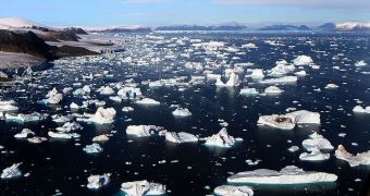
A team of investigators from the United Kingdom says that its current research effort, of peering at the geophysical and hydrological conditions below the surface of the Greenland ice sheets, are critically important for the future.
They believe that this line of study could help us better understand the ensemble of conditions that eventually lead to a breakdown of the sheets, and to the production of countless, smaller icebergs.
Sometimes, the resulting iceberg is not so small. Recently, the Petermann Glacier lost a piece of ice four times the size of Manhattan, and which could block the Nares Strait entirely.
Understanding how the ice age responds to climate change and global warming is one of the most important goals of science today.
At this point, it's known that the warming ocean is heating up the ice sheets from underneath, but the exact mechanisms that make the ice melt, as well as those delaying the inevitable, are still a mystery.
“We know little about how water flows beneath the Greenland Ice Sheet because the toolkit available to scientists to trace waters under such challenging conditions has been very limited,” explains Dr Jemma Wadham, the leader of the research initiative.
“We aim to employ a new suite of highly sensitive tracing methods, developed in Bristol, to solve this mystery,” the expert adds.
The research effort will be conducted by scientists at the Bristol Glaciology Center, who will be collaborating with colleagues from the UB Faculty of Engineering.
Over the past few years, researchers at the University of Bristol have been conducting extensive investigations in Greenland, measuring ice sheet thickness and collecting samples for analysis.
Experts from the universities of Aberystwyth, Cambridge, Edinburgh, and Texas will also collaborate in the work, as will experts from the Woods Hole Oceanographic Institution (WHOI), the NASA Jet Propulsion Laboratory (JPL) and the Greenland Geological Survey.
Data collected from ground-based tracers will be combined with airborne observations, to create the most comprehensive map of the influences at work in the area.
“Together these […] projects will provide important insights and new information on the factors that control basal processes and motion beneath the 1-3 km thickness of ice that covers most of Greenland,” explains UB professor Jonathan Bamber.
Greenland contains so much ice that, if it were to melt, it would raise global sea levels by more than seven meters, or 23 feet.

 14 DAY TRIAL //