China is one of the countries located in areas of intense seismic activity, a fact that over the millennia has made itself felt on numerous occasions. Accounts of devastating earthquakes can be found throughout the nation's history; thus, experts in the country have formed a mixed Chinese-European research group, bent on using satellite data to better understand seismic cycles, as well as how the faults behave over time. The investigation mostly focuses on the largest faults, with the smaller ones being studied as a secondary objective.
The research team is united in the European Space Agency's Dragon 2 Program, which uses a number of observation techniques to assess changes at ground level. Among the most important instruments and methods used for these observations, experts mention GPS data, Synthetic Aperture Radar (SAR) satellite data, as well as SAR Interferometry (InSAR), which allows for the combination of multiple radar readings in very much the same way interferometry works in telescopes, ScienceDaily informs.
The advantages of the new system immediately became apparent after the Wenchuan earthquake, which struck the Sichuan Province last May, causing many deaths, thousands of refugees, and millions of dollars in damages. “Combining InSAR with GPS data, we have learned that some regions on the fault did not rupture that much during the earthquake,” says Institute of Geology, China Earthquake Administration (IGCEA) expert Shen Zhengkang, who is also a professor at the Peking University.
“We must then ask ourselves if the energy is still partially locked and therefore continuously accumulating for the next ‘big one’, or perhaps there was not that much energy accumulated in the regions prior to the quake. By combining the co- and post-seismic study results, we are about to answer these questions. If the area is moving slowly after the quake, then we know it is not accumulating energy, so we believe it to be safe. If, however, one area on the fault is not slipping but there is creeping movement around it, then we know that is a bad sign and we have to watch it more carefully,” he says.
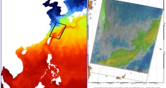
“The radial Doppler velocity map shows the strong southwest-to-northeast motion associated with the path shown in the sea-surface temperature model, so it confirms the velocity pattern associated with the Kuroshio Current. Since we removed the effects of wind and waves, what is shown is close to a picture of the pure surface current projected in the SAR-looking direction,” concludes Nansen Environmental and Remote Sensing Center, professor Johnny Johannessen.

 14 DAY TRIAL //