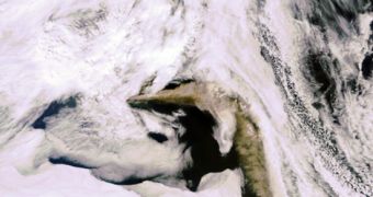
On May 6, the European Space Agency (ESA) Earth-observing satellite Envisat captured a new image of the ash plumes that have been produced by the renewed eruption of the Eyjafjallajoekull volcano, in Iceland. The massive ash plumes have been determined to be covering an area of about 1,600 kilometers above the Atlantic Ocean, and to be of a brownish color. After first erupting, the cloud headed eastwards, and then began moving south, forcing airlines to again shut down airports at several locations around the European Union.
The plume is clearly defined in this new photograph, contrasting strongly with the white clouds that frame Envisat's field-of-view. The Eyjafjallajoekull glaciovolcano first began spewing out ash and lava on March 20, and has released tons upon tons of dangerous particles in the air ever since. The scale of the disaster at the time prompted EU officials to shut down a large number of major airports, which in turn caused damages of around 1.3 billion euros to the aviation industry. At the beginning of this week, the volcano renewed its activity, which again forced officials to shut down inbound and outbound flights to and from Ireland, Northern Ireland and Scotland.
Glaciovolcanoes, such as Iceland's Eyjafjallajoekull, are similar to the “regular” ones in most aspects, other than the fact that they are covered with ice and glaciers. The interplay between the erupting magma and gas and the ice spreads on top can generate very bad consequences for the area around the volcano. One of the most devastating side-effects is floods. They are called “jokulhlaups” in Iceland, and scientists in the country were fortunately ready for them when the glaciovolcano erupted.
According to geologists, it would appear that a huge pocket of magma exists below Iceland. They say that magma seeping up from this layer may have begun to solidify, and that eventually it started to form the basis for the island. The 200 volcanoes this small country houses are living proof that it was tectonic processes that allowed it to develop in the first place, say investigators from the San Francisco Exploratorium museum. Iceland geologists say that this particular glaciovolcano erupted last some 200 years ago.
Launched in 2002, Envisat is the largest Earth Observation spacecraft ever built. It carries ten sophisticated optical and radar instruments to provide continuous observation and monitoring of the Earth's land, atmosphere, oceans and ice caps. Envisat data collectively provide a wealth of information on the workings of the Earth system, including insights into factors contributing to climate change.

 14 DAY TRIAL //