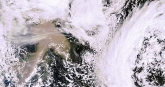
Experts say that it may be possible to use satellite monitoring data to get relatively accurate predictions as to how ash plumes emitted by volcanoes might spread in the surrounding regions. This is essential for flying airplanes safely, but also for preventing air catastrophes.
This discussion was again brought into focus by this week's eruption that shook the Grímsvötn volcano in Iceland. The devastation caused by the Eyjafjallajoekull volcano less than a year ago is still vivid across Europe and the world.
Scientists admit that predicting ash cloud dispersal patterns will never be easy. At the same time, they are also saying that carrying out computer simulations might at least give authorities a clue as to what they will be facing in the days following an eruption.
For example, satellite data collected by spacecraft observing the Grímsvötn volcano indicated early on that this particular ash cloud would most likely not make its way over central Europe's busy air space.
Although these effects were not as harmful as last year's, Europe still had to ground an estimated 1,000 flights to various destinations, just to err on the side of caution, experts with the European Space Agency (ESA) say.
They add that the The Icelandic Met Office is now reporting zero tons of ash being produced from the volcano. Grímsvötn erupted on the evening of May 21, and injected huge amounts of ash high up in planet's atmosphere.
ESA believes that its satellites could measure the spread, extension, concentration and movement of volcanic plumes, and provide these vital data to authorities across the entire continent. Some spacecraft in Earth's orbit send back data ever 15 minutes or so.
Over the past few days, ash from Grímsvötn drifted mostly over Scotland and Scandinavia, and did not make its way to mainland Europe. “Measurements from polar-orbiting satellites are confirming these findings,” ESA reports.
“The MERIS optical instrument on ESA's Envisat satellite captured the position of the ash cloud close to Iceland and Scotland on May [24 and 25]. These images are consistent with the data observed by the SEVIRI,” the agency says in a press release.
SEVIRI is the Spinning Enhanced Visible and Infrared Imager instrument on the MSG-2 satellite.

 14 DAY TRIAL //