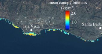
The kelp forests developing in the Santa Barbara Channel have recently been imaged by satellite in Earth's orbit. At the same time, researchers conducted an in-situ investigation, which ultimately provided them with the most comprehensive view to date on the structure.
Marine biologists explain that kelps are a group of 30 genera of large algal seaweeds, which belong to the brown algae family Phaeophyceae. These organisms tend to grow in tightly-knit communities called forests, and they are most often found in shallow waters, especially along shorelines.
Members of the kelp genera Macrocystis and Nereocystis can grow so fast that they exceed a rate of 30 centimeters per day. When they stop growing, these algae are between 30 and 80 meters long.
The Pacific Ocean features one such gigantic kelp forest, which is located in and around the Santa Barbara Channel. Between 1984 and 2009, researchers have kept a close eye on these ecosystems.
The goal of the research was to determine the environmental factors that affect the growth of these algae, and also events that influence their well-being. Studies to assess these dangers were conducted both by scuba divers and satellites.
In the latest issue of the scientific journal Marine Ecology Progress Series, experts published a paper detailing how the kelp forest evolved over the past 25 years. The orbital data were obtained from the Landsat 5 Thematic Mapper satellite.
University of California in Santa Barbara (UCSB) expert and paper coauthor David Siegel says that obtaining so many years-worth of consistent data from a single source is unprecedented.
“A satellite mission that goes on for more than 10 years is rare. One that continues for more than 25 years is a miracle,” Siegel explains. The team did not work with satellite managers directly.
Back in 2009, all the data this Landsat spacecraft collected were made freely available to the public, and experts jumped at the opportunity to put them together in a viable dataset.
“In the past, it wasn't feasible to develop long time-series using Landsat images. Once these data were released free of charge, however, we could access hundreds of pictures that show an area over time,” adds UCSB expert and lead paper author Kyle Cavanaugh.
“Giant kelp forms a dense floating canopy at the sea surface that's distinctive when viewed from above. Water absorbs almost all incoming near-infrared energy, so the kelp canopy is easily differentiated using its near-infrared reflectance signal,” the new paper reads.
It was also found that large waves control the size of the kelp forest in exposed oceanic areas. In more hidden regions, low nutrient levels keep algal growth in check, experts with the US National Science Foundation (NSF) report.

 14 DAY TRIAL //