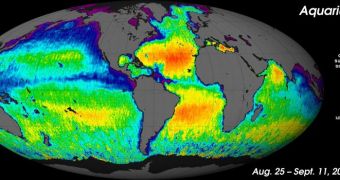
The Aquarius instrument aboard the SAC-D (Satélite de Aplicaciones Científicas) spacecraft has recently acquired sufficient data to produce its first global salinity map. The dataset has been released yesterday, September 22.
One of the main reasons why NASA collaborated with Argentina on this project is because the American space agency wanted access to a spacecraft capable of measuring subtle salt concentration variations throughout the world's oceans.
The information SAC-D collects can be used to gain a deeper understanding about how our planet's natural cycles are set up. This in turn might help us understand our climate better, as well as which of our actions affect it, and how.
Two of the most important natural cycles that are influenced by salinity are the freshwater cycles on Earth's surface and atmosphere, as well as circulation and current patterns through its oceans.
The salinity patterns included in the new map indicate that Aquarius – the main American contribution to the joint mission – is capable of measuring salt concentrations with sharp contrast and an unmatchable level of detail.
According to experts from the NASA Jet Propulsion Laboratory (JPL), in Pasadena, California, SAC-D began collecting data on August 25. The final pieces of information to make their way into this new map were collected on September 11.
“Aquarius' salinity data are showing much higher quality than we expected to see this early in the mission. Aquarius soon will allow scientists to explore the connections between global rainfall, ocean currents and climate variations,” Gary Lagerloef explains.
The expert, who holds an appointment at Seattle-based Earth & Space Research, is the principal investigator of the Aquarius instrument. The SAC-D spacecraft took off on June 10, 2011, from the Vandenberg Air Force Base, in California.
“Aquarius/SAC-D already is advancing our understanding of ocean surface salinity and Earth's water cycle. Aquarius is making continuous, consistent, global measurements of ocean salinity, including measurements from places we have never sampled before,” Michael Freilich adds.
The official is the director of the NASA Earth Science Division, at the space agency's Headquarters in Washington, DC. The Aquarius instrument was built by experts at JPL and the Goddard Space Flight Center (GSFC), in Greenbelt, Maryland.
“Aquarius has exposed a pattern of ocean surface salinity that is rich in variability across a wide range of scales. This is a great moment in the history of oceanography. The first image raises many questions that oceanographers will be challenged to explain,” Aquarius science team member Arnold Gordon says.
The expert holds an appointment as a professor of oceanography at the Columbia University, and also works for the Lamont-Doherty Earth Observatory at the university.

 14 DAY TRIAL //