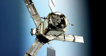
The European Space Agency (ESA), the operator of the newly-launched Soil Moisture and Ocean Salinity Satellite (SMOS), has announced today that the instrument has successfully deployed its three-antenna arms, which was the most delicate process in the commissioning phase. The Living Planet Program components are currently in good health, and are undergoing calibration and other preliminary procedures ahead of beginning actual scientific measurements. The satellite was launched from the Plesetsk Cosmodrome, 800 kilometers away from Moscow, in Russia, on November 2.
The main instrument aboard the spacecraft is the Microwave Imaging Radiometer with Aperture Synthesis (MIRAS). Its main components are a central hub, as well as the recently-deployed arms. Now, when fully deployed, the instrument is larger than its carrying platform, and measures about 8 meters from the arm tip to arm tip. The antennas are extremely important because they carry most of the 69 smaller antenna receivers that make up MIRASA. These instruments are called LICEFs.
The thing about them is that they act like a much larger antenna than they may appear. They relay on interferometry to combine their individual readings. The technique is also used in radio telescope arrays, so as to make 10-20 dishes act like a single one, with a diameter equal to the largest distance between the individual observers. This is the only way to make the orbital instrument accurate and powerful enough to pick up global data on soil moisture and ocean salinity.
The main goal of SMOS' mission is to analyze the faint radio waves that are emitted through the top layer of the soil and sea water. According to hydrologists, the strength of these signals can be used as a clear indicator of how much water there is in the ground, information that, in turn, could be used to anticipate floods earlier than currently possible, and also to improve weather forecasts. In spite of the fact that it will do this roughly, SMOS will be the first satellite of this type to perform a global measurement of these readings, ESA officials say.
“Soil moisture levels actually form the basis for every hydrologist. Using them, along with other information, you can make decisions on such matters as flooding, drought, desertification and regional weather. Good data on soil moisture levels, however, is scarce. Up to now, you had to go out into the field with a shovel, in a manner of speaking, in order to map out soil moisture levels. That is all going to change with the SMOS (Soil Moisture and Ocean Salinity) satellite,” TU Delft expert, Professor Nick van de Giesen explains.

 14 DAY TRIAL //