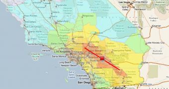
Live Search Maps and Virtual Earth go well beyond the mapping, location and search capabilities, and the adjacent Oblique (Bird's Eye), Ortho, Aerial and satellite imagery which can very easily take center stage. The fact of the matter is that Microsoft is touting Virtual Earth as a fully fledged cloud platform, and Inlet (Internet-based Loss Estimation Tool) comes as an illustrative example in this regard. Defined as a "web-based loss estimation and transportation modeling platform" the tool is capable of assessing the impact that Information Technology (IT) solutions have on reducing the level of damages in critical scenarios.
"INLET currently incorporates GIS, a risk model, and a transportation model to provide online estimates for building damage, transportation impacts, and casualties. Additional features include a demonstration of a model simulating the effect of IT on evacuation routing. Specifically, the model illustrates how awareness of a disaster scenario and familiarity with routing alternatives can impact traffic congestion and evacuation time," revealed Chris Pendleton, Virtual Earth technical evangelist.
Essentially, Inlet will permit end users to run earthquake simulations on top of Microsoft Virtual Earth. The tool enables users to select the potential epicenter of an earthquake with a magnitude between 5 and 9 on the Richter scale. Selecting the epicenter's longitude and latitude can be done with a simple click of the mouse on the Virtual Earth map.
However, there are additional settings that must be configured in order to produce a wide variety of simulation scenarios, from Ground Motion to injuries and casualties. A number of USGS earthquake planning scenarios are also available for end users. The main shortcoming of Inlet is the fact that its reach is limited only to California, US. "The application also includes USGS Earthquake Simulations (ShakeMap), Census Track Results, Thematic Mapping, and plotting of facilities," Pendleton added.

 14 DAY TRIAL //