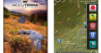
3D digital mapping company Intermap Technologies has issued a new version of its AccuTerra application for iPhone and iPod touch. Immediately available for download from the iTunes App Store, the updated app includes the first detailed map download from the AccuTerra map store, and is currently free.
Providing quick, one-touch access to all the major mapping functions right on the device, the AccuTerra application records treks, creates waypoints, accesses options, all while allowing the user to toggle between different map views.
The company developing the application claims to have improved “In-App” shopping in order to allow users to easily purchase 247 high-definition maps, including 167 recreation areas, 23 state parks, and 57 national parks. Access to purchase 77 detailed state maps has also been added. These are easily downloadable onto the iPhone as well, AccuTerra claims, via an official report issued this week. Google Maps access for urban on-road data is also a new feature. Lastly, the company mentions the addition of a simple toggle button to switch between Google content and AccuTerra off-road maps.
However, by visiting the app’s iTunes store page, we can see there’s one other new feature that the official press release fails to mention. In fact, it’s more exciting than all those listed above put together: “the ability to record your adventures, and take pictures in Google Maps Mode.”
“The addition of Google Maps access is extremely helpful for AccuTerra users who conduct excursions straddling the boundaries between urban settings and the backcountry, where AccuTerra’s off-road map coverage is second to none. With the addition of new mapping data, AccuTerra now provides more than 5.5 million square miles of wide-area coverage and more than 745,000 square miles of high-definition, super zoom backcountry and trail maps,” Michael Bullock, vice president, Intermap Consumer Electronics, said. “AccuTerra continues to establish itself as the de facto standard on the iPhone for backcountry mapping, even as it begins to broaden its reach into the urban setting by providing on-road data and map imagery.”
The AccuTerra application requires iPhone OS 3.0 or later and is compatible with all iPhone and iPod touch models.

 14 DAY TRIAL //