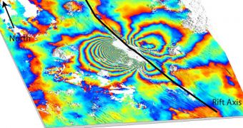
Predicting where volcanic eruptions will strike next would be an important asset for nations exhibiting elevated risks of suffering the effects of such events. Now, satellite data are helping with this quest.
Using orbital observatories, experts hope to become able to predict where the next large eruptions will take place, based on the effects that past eruptions in the same region had on the surrounding landscape.
This line of study is similar to the one investigating earthquakes. When a tremor occurs in a region, it can place stress on nearby fault lines, elevating the risk for subsequent quakes.
Up until now, there have been little conclusive evidence to support a similar scenario in regards to volcanic eruptions, but new data from the Envisat satellite have provided the necessary proof.
The European Space Agency (ESA) is collaborating with experts in the United Kingdom, the United States, and Ethiopia, in producing viable radar data of a volcano in the African nation.
The mountain, located in the Ethiopian Afar Desert, erupted back in September 2005, and this event forced underground magma upwards through a dyke, which is basically a crack in Earth's surface.
The end result of this event was the creation of a 60-kilometer-long tear in the planetary crust, which led to the appearance of 12 more dykes in the same area over the next 4 years.
Envisat has been observing the area since the volcanic event took place, checking to see how stress levels in the ground change over time, potentially yielding clues to future eruptions.
Magma moves below the surface of the Earth through complex underground chamber systems. As vast amounts of molten rock pass from one chamber to the other, they create visible effects on the surface.
The land above the emptied chambers deflates, whereas those above chambers where magma accumulates inflate.
An observations technique known as synthetic aperture radar interferometry (InSAR) can detect these surface changes, and produce “interferogram” images of the variations. Envisat has such an instrument.
Data from the satellite seem to indicate that subsequent eruptions which rocked the desert had the same sources, experts write in the latest issue of the esteemed scientific journal Nature Geoscience.
They believe that the dykes which developed following the primary eruption did not appear at random. About 75 percent of them originated in areas that had been disturbed by the appearance of the 2005 dyke.
“This result indicates that stress changes induced by a new dyke are a controlling factor on the location of future events, so surface deformation should be routinely monitored to improve volcanic hazard warnings,” says expert Dr Ian Hamling.
“Knowing the state of stress in this way won't tell you when an eruption will happen, but it will give a better idea of where it is most likely to occur,” adds the scientist, who is the lead author of the study.
He also holds an appointment with the International Center for Theoretical Physics.
“These findings are unique and will help us better predict the location of future eruptions and help authorities issue timely evacuation warnings,” adds University of Leeds expert and study coauthor Dr Tim Wright.
“Regular Envisat satellite passes have allowed us to build a unique dataset, without which it would not have been possible to test the idea that stress controls the location of future activity,” he concludes.

 14 DAY TRIAL //