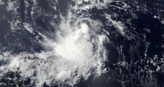
The picture above was taken by the MODIS (Moderate Resolution Imaging Spectroradiometer) instrument aboard NASA's Aqua satellite this past July 7, at 12:15 EDT.
It shows tropical storm Chantal circling over the waters off Brazil's coastline.
EurekAlert explains that, at the time when the picture was taken, the most powerful thunderstorms spawned by this tropical storm were close to the center of circulation.
Unlike the other two tropical storms that have formed as part of this year's hurricane season, Chantal emerged not in the Gulf of Mexico, but in the Atlantic Ocean.
Specialists say that the storm will leave the Lesser Antilles this Tuesday. It will most likely head towards the eastern regions of the Caribbean Sea.
By the looks of it, the storm is moving at a speed of 26 miles per hour (43 kilometers per hour). Odds are it will maintain this speed until it reaches the Caribbean Sea and dies out.

 14 DAY TRIAL //