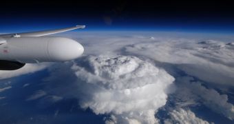
Just a few days ago, NASA released this photo showing a massive cloud hovering over North Carolina, US. The cloud, shaped like a dome, formed during a thunderstorm that hit the region earlier this year, in May.
The photo was taken by a pilot named Stu Broce, who was flying over North Carolina at the time the thunderstorm came into being and started dumping loads of hail on this part of the country.
As detailed by NASA, this thunderstorm that pilot Stu Broce managed to photograph while cruising over it stood about 50,000 feet (approximately 15,000 meters) tall.
The reason the pilot was able to snap some pictures of it without putting himself in danger was that his aircraft was flying at an altitude of about 65,000 feet (roughly 20,000 meters), NASA further explains.
By the looks of it, such odd clouds are known to the scientific community as overshooting tops. According to NASA researchers, “Overshooting tops are dome-like protrusions at the top of thunderstorms that provide evidence of very strong updrafts.”
In case anyone was wondering, Stu Broce did not just happen to be in the region at the time the thunderstorm formed. On the contrary, he purposely flew over it and photographed it as part of a research into precipitation over mountainous terrain.

 14 DAY TRIAL //